Itirapina geodata
Itirapina (São Paulo) is a populated place; located in Brazil in America/Sao_Paulo (GMT-3) time zone. With population of 13,229 people, there are 1353 cities with bigger population in this country. Compared to other cities in Brazil, 71.6% of cities are located further ↑North; 63.6% of cities are located further →East and 85.2% of cities have lower elevation than Itirapina. Note1


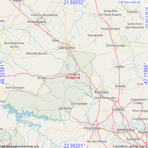
Itirapina GPS coordinates[2]
22° 15' 10.008" South, 47° 49' 22.008" West
| Map corner | latitude | longitude |
|---|---|---|
| Upper-left | -21.60052°, | -48.52591° |
| Center: | -22.25278°, | -47.82278° |
| Lower-right: | -22.90201°, | -47.11966° |
| Map W x H: | 144.7×144.7 km | = 89.9×89.9mi |
| max Lat: | 2.81972° ⇑71.6% North |
| Itirapina: | -22.25278° |
| min Lat: | ⇓28.4% South -33.69111° |
| min Long | Itirapina | max Long |
| -72.89583° | -47.82278° | -32.41083° |
| W 36.4%⇐ | ⇒63.6% E |
Elevation
Elevation of Itirapina is 760 m = 2493 ft, and this is 379.1 m = 1244 ft above average elevation for this country.
| Max E: |
1603 m = 5259 ft | 14.8% |
| Itirapina | 760 m 2493 ft | |
| Avg. | 380.9 m = 1250 ft | |
Min E: |
0 m = 0 ft | 85.2% |
See also: Brazil elevation on elevation.city.
Geographical zone
Itirapina is located in South Torrid zone (between Equator and Tropic of Capricorn). Distance of this Southern Tropic circle is 131.6 km =81.8 mi to South.| Distance of | km | miles | from Itirapina |
|---|---|---|---|
| Equator | 2474.3 | 1537.5 | to North |
| Tropic Capricorn | 131.6 | 81.8 | to South |
| Antarctic Circle | 4926.9 | 3061.4 | to South |
| South Pole | 7532.8 | 4680.7 | to South |


Nearby cities:
15 places around Itirapina: (largest is in red/bold)
• Araras
46.6 km =29 mi,  104°
104°
• Brotas
31.5 km =19.6 mi,  263°
263°
• Charqueada
28.9 km =18 mi,  170°
170°
• Cordeirópolis
45.5 km =28.3 mi,  124°
124°
• Descalvado
44.1 km =27.4 mi,  28°
28°
• Ibaté
37.7 km =23.4 mi,  331°
331°
• Iracemápolis
48 km =29.8 mi,  139°
139°
• Leme
45.1 km =28 mi,  80°
80°
• Limeira
55.5 km =34.5 mi,  128°
128°
• Pirassununga
49.9 km =31 mi,  55°
55°
• Ribeirão Bonito
41.9 km =26 mi,  299°
299°
• Rio Claro
32.2 km =20 mi, 123°
• Santa Gertrudes
37.7 km =23.4 mi, 127°
• São Carlos
27.1 km =16.8 mi,  345°
345°
• São Pedro
34.2 km =21.3 mi,  195°
195°
Sources, notices
• [Note1] Compared only with cities in Brazil existing in our database
• [Src1] Map data: © OpenStreetMap contributors (CC-BY-SA)
• [Src2] Other city data from geonames.org with taken over terms of usage.
• [Src3] Geographical zone / Annual Mean Temperature by Robert A. Rohde @ Wikipedia
