Pirassununga geodata
Pirassununga (São Paulo) is a populated place; located in Brazil in America/Sao_Paulo (GMT-3) time zone. With population of 60,413 people, there are 367 cities with bigger population in this country. Compared to other cities in Brazil, 70.1% of cities are located further ↑North; 61% of cities are located further →East and 75.4% of cities have lower elevation than Pirassununga. Note1


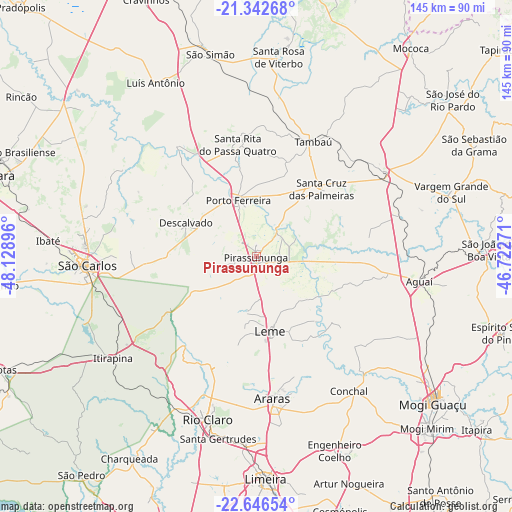
Pirassununga GPS coordinates[2]
21° 59' 45.996" South, 47° 25' 32.988" West
| Map corner | latitude | longitude |
|---|---|---|
| Upper-left | -21.34268°, | -48.12896° |
| Center: | -21.99611°, | -47.42583° |
| Lower-right: | -22.64654°, | -46.72271° |
| Map W x H: | 145×145 km | = 90.1×90.1mi |
| max Lat: | 2.81972° ⇑70.1% North |
| Pirassununga: | -21.99611° |
| min Lat: | ⇓29.9% South -33.69111° |
| min Long | Pirassununga | max Long |
| -72.89583° | -47.42583° | -32.41083° |
| W 39%⇐ | ⇒61% E |
Elevation
Elevation of Pirassununga is 631 m = 2070 ft, and this is 250.1 m = 821 ft above average elevation for this country.
| Max E: |
1603 m = 5259 ft | 24.6% |
| Pirassununga | 631 m 2070 ft | |
| Avg. | 380.9 m = 1250 ft | |
Min E: |
0 m = 0 ft | 75.4% |
See also: Pirassununga elevation on elevation.city.
Geographical zone
Pirassununga is located in South Torrid zone (between Equator and Tropic of Capricorn). Distance of this Southern Tropic circle is 160.2 km =99.5 mi to South.| Distance of | km | miles | from Pirassununga |
|---|---|---|---|
| Equator | 2445.7 | 1519.7 | to North |
| Tropic Capricorn | 160.2 | 99.5 | to South |
| Antarctic Circle | 4955.4 | 3079.1 | to South |
| South Pole | 7561.3 | 4698.4 | to South |


Nearby cities:
15 places around Pirassununga: (largest is in red/bold)
• Aguaí
46.6 km =29 mi,  98°
98°
• Araras
40.3 km =25 mi,  173°
173°
• Casa Branca
42.9 km =26.7 mi,  54°
54°
• Conchal
45.4 km =28.2 mi,  144°
144°
• Cordeirópolis
54.1 km =33.6 mi,  183°
183°
• Descalvado
22.4 km =13.9 mi,  297°
297°
• Itirapina
49.9 km =31 mi,  235°
235°
• Leme
21.4 km =13.3 mi, 170°
• Porto Ferreira
16.7 km =10.4 mi,  340°
340°
• Rio Claro
48.2 km =30 mi,  196°
196°
• Santa Cruz das Palmeiras
26.2 km =16.3 mi,  44°
44°
• Santa Gertrudes
52.3 km =32.5 mi,  191°
191°
• Santa Rita do Passa Quatro
32.2 km =20 mi,  350°
350°
• São Carlos
48 km =29.8 mi,  267°
267°
• Tambaú
35.9 km =22.3 mi,  25°
25°
Sources, notices
• [Note1] Compared only with cities in Brazil existing in our database
• [Src1] Map data: © OpenStreetMap contributors (CC-BY-SA)
• [Src2] Other city data from geonames.org with taken over terms of usage.
• [Src3] Geographical zone / Annual Mean Temperature by Robert A. Rohde @ Wikipedia
