Aguaí geodata
Aguaí (São Paulo) is a populated place; located in Brazil in America/Sao_Paulo (GMT-3) time zone. With population of 27,503 people, there are 720 cities with bigger population in this country. Compared to other cities in Brazil, 70.3% of cities are located further ↑North; 58.5% of cities are located further →East and 77.8% of cities have lower elevation than Aguaí. Note1


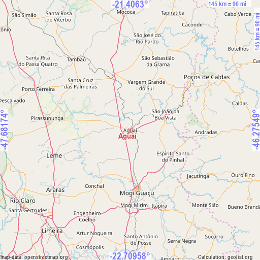
Aguaí GPS coordinates[2]
22° 3' 33.984" South, 46° 58' 42.996" West
| Map corner | latitude | longitude |
|---|---|---|
| Upper-left | -21.4063°, | -47.68174° |
| Center: | -22.05944°, | -46.97861° |
| Lower-right: | -22.70958°, | -46.27549° |
| Map W x H: | 144.9×144.9 km | = 90×90mi |
| max Lat: | 2.81972° ⇑70.3% North |
| Aguaí: | -22.05944° |
| min Lat: | ⇓29.7% South -33.69111° |
| min Long | Aguaí | max Long |
| -72.89583° | -46.97861° | -32.41083° |
| W 41.5%⇐ | ⇒58.5% E |
Elevation
Elevation of Aguaí is 665 m = 2182 ft, and this is 284.1 m = 932 ft above average elevation for this country.
| Max E: |
1603 m = 5259 ft | 22.2% |
| Aguaí | 665 m 2182 ft | |
| Avg. | 380.9 m = 1250 ft | |
Min E: |
0 m = 0 ft | 77.8% |
See also: Brazil elevation on elevation.city.
Geographical zone
Aguaí is located in South Torrid zone (between Equator and Tropic of Capricorn). Distance of this Southern Tropic circle is 153.1 km =95.1 mi to South.| Distance of | km | miles | from Aguaí |
|---|---|---|---|
| Equator | 2452.8 | 1524.1 | to North |
| Tropic Capricorn | 153.1 | 95.1 | to South |
| Antarctic Circle | 4948.4 | 3074.8 | to South |
| South Pole | 7554.3 | 4694 | to South |


Nearby cities:
15 places around Aguaí: (largest is in red/bold)
• Andradas
42.2 km =26.2 mi,  91°
91°
• Casa Branca
33.6 km =20.9 mi,  340°
340°
• Conchal
36.1 km =22.4 mi,  213°
213°
• Espírito Santo do Pinhal
31.1 km =19.3 mi,  101°
101°
• Itapira
44.9 km =27.9 mi,  158°
158°
• Jacutinga
45.3 km =28.1 mi,  123°
123°
• Leme
44.7 km =27.8 mi,  251°
251°
• Mogi Guaçu
34.4 km =21.4 mi,  174°
174°
• Mogi Mirim
41.5 km =25.8 mi,  177°
177°
• Pirassununga
46.6 km =29 mi,  278°
278°
• Santa Cruz das Palmeiras
38 km =23.6 mi,  312°
312°
• São José do Rio Pardo
52.4 km =32.6 mi,  10°
10°
• São João da Boa Vista
21.1 km =13.1 mi,  61°
61°
• Tambaú
49.8 km =30.9 mi,  322°
322°
• Vargem Grande do Sul
26.7 km =16.6 mi,  19°
19°
Sources, notices
• [Note1] Compared only with cities in Brazil existing in our database
• [Src1] Map data: © OpenStreetMap contributors (CC-BY-SA)
• [Src2] Other city data from geonames.org with taken over terms of usage.
• [Src3] Geographical zone / Annual Mean Temperature by Robert A. Rohde @ Wikipedia
