Buri geodata
Buri (São Paulo) is a populated place; located in Brazil in America/Sao_Paulo (GMT-3) time zone. With population of 15,958 people, there are 1160 cities with bigger population in this country. Compared to other cities in Brazil, 85.1% of cities are located further ↑North; 68.6% of cities are located further →East and 73% of cities have lower elevation than Buri. Note1


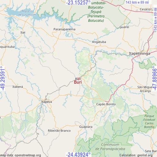
Buri GPS coordinates[2]
23° 47' 51" South, 48° 35' 34.008" West
| Map corner | latitude | longitude |
|---|---|---|
| Upper-left | -23.15257°, | -49.29591° |
| Center: | -23.7975°, | -48.59278° |
| Lower-right: | -24.43924°, | -47.88966° |
| Map W x H: | 143.1×143.1 km | = 88.9×88.9mi |
| max Lat: | 2.81972° ⇑85.1% North |
| Buri: | -23.7975° |
| min Lat: | ⇓14.9% South -33.69111° |
| min Long | Buri | max Long |
| -72.89583° | -48.59278° | -32.41083° |
| W 31.4%⇐ | ⇒68.6% E |
Elevation
Elevation of Buri is 603 m = 1978 ft, and this is 222.1 m = 729 ft above average elevation for this country.
| Max E: |
1603 m = 5259 ft | 27% |
| Buri | 603 m 1978 ft | |
| Avg. | 380.9 m = 1250 ft | |
Min E: |
0 m = 0 ft | 73% |
See also: Brazil elevation on elevation.city.
Geographical zone
Buri is located in South temperate zone (between Tropic of Capricorn and the Antarctic Circle). Distance of this Southern Tropic circle is 40.1 km =24.9 mi to North.| Distance of | km | miles | from Buri |
|---|---|---|---|
| Equator | 2646 | 1644.1 | to North |
| Tropic Capricorn | 40.1 | 24.9 | to North |
| Antarctic Circle | 4755.1 | 2954.7 | to South |
| South Pole | 7361 | 4573.9 | to South |


Nearby cities:
15 places around Buri: (largest is in red/bold)
• Angatuba
38.8 km =24.1 mi,  28°
28°
• Apiaí
83.1 km =51.6 mi,  197°
197°
• Avaré
84.8 km =52.7 mi,  336°
336°
• Capâo Bonito
33.9 km =21.1 mi,  133°
133°
• Itaberá
55.8 km =34.7 mi,  262°
262°
• Itapetininga
59.5 km =37 mi,  67°
67°
• Itapeva
35.3 km =21.9 mi,  234°
234°
• Itararé
82.8 km =51.4 mi,  244°
244°
• Itatinga
77.4 km =48.1 mi,  358°
358°
• Itaí
66 km =41 mi,  309°
309°
• Paranapanema
47.6 km =29.6 mi, 343°
• Pilar do Sul
89.2 km =55.4 mi,  91°
91°
• Porangaba
84 km =52.2 mi, 34°
• Ribeirão Branco
50.2 km =31.2 mi, 200°
• Taquarituba
72.6 km =45.1 mi,  293°
293°
Sources, notices
• [Note1] Compared only with cities in Brazil existing in our database
• [Src1] Map data: © OpenStreetMap contributors (CC-BY-SA)
• [Src2] Other city data from geonames.org with taken over terms of usage.
• [Src3] Geographical zone / Annual Mean Temperature by Robert A. Rohde @ Wikipedia
