Itupeva geodata
Itupeva (São Paulo) is a populated place; located in Brazil in America/Sao_Paulo (GMT-3) time zone. With population of 20,605 people, there are 918 cities with bigger population in this country. Compared to other cities in Brazil, 80% of cities are located further ↑North; 59% of cities are located further →East and 78.8% of cities have lower elevation than Itupeva. Note1


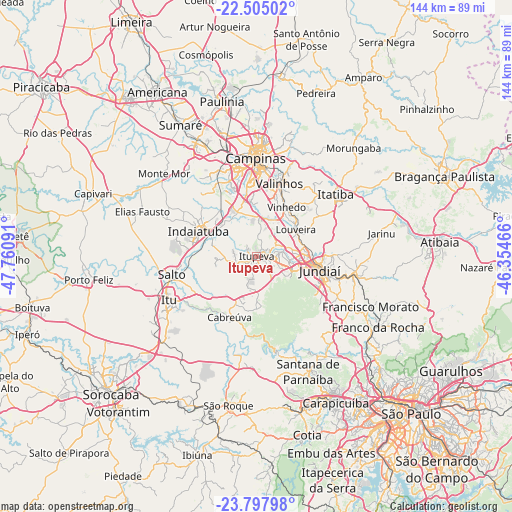
Itupeva GPS coordinates[2]
23° 9' 11.016" South, 47° 3' 28.008" West
| Map corner | latitude | longitude |
|---|---|---|
| Upper-left | -22.50502°, | -47.76091° |
| Center: | -23.15306°, | -47.05778° |
| Lower-right: | -23.79798°, | -46.35466° |
| Map W x H: | 143.8×143.8 km | = 89.4×89.4mi |
| max Lat: | 2.81972° ⇑80% North |
| Itupeva: | -23.15306° |
| min Lat: | ⇓20% South -33.69111° |
| min Long | Itupeva | max Long |
| -72.89583° | -47.05778° | -32.41083° |
| W 41%⇐ | ⇒59% E |
Elevation
Elevation of Itupeva is 676 m = 2218 ft, and this is 295.1 m = 968 ft above average elevation for this country.
| Max E: |
1603 m = 5259 ft | 21.2% |
| Itupeva | 676 m 2218 ft | |
| Avg. | 380.9 m = 1250 ft | |
Min E: |
0 m = 0 ft | 78.8% |
See also: Brazil elevation on elevation.city.
Geographical zone
Itupeva is located in South Torrid zone (between Equator and Tropic of Capricorn). Distance of this Southern Tropic circle is 31.5 km =19.6 mi to South.| Distance of | km | miles | from Itupeva |
|---|---|---|---|
| Equator | 2574.4 | 1599.7 | to North |
| Tropic Capricorn | 31.5 | 19.6 | to South |
| Antarctic Circle | 4826.8 | 2999.2 | to South |
| South Pole | 7432.7 | 4618.5 | to South |


Nearby cities:
15 places around Itupeva: (largest is in red/bold)
• Cabreúva
18.8 km =11.7 mi,  204°
204°
• Cajamar
29.2 km =18.1 mi,  140°
140°
• Campinas
27.5 km =17.1 mi,  359°
359°
• Campo Limpo Paulista
28.6 km =17.8 mi,  101°
101°
• Indaiatuba
17.3 km =10.7 mi,  294°
294°
• Itatiba
27.7 km =17.2 mi,  53°
53°
• Itu
27.6 km =17.1 mi,  243°
243°
• Jarinu
34.2 km =21.3 mi,  80°
80°
• Jundiaí
18.1 km =11.2 mi, 101°
• Louveira
13.2 km =8.2 mi,  55°
55°
• Pirapora do Bom Jesus
27.7 km =17.2 mi,  168°
168°
• Salto
24 km =14.9 mi,  257°
257°
• Valinhos
21.3 km =13.2 mi,  17°
17°
• Vinhedo
16.1 km =10 mi,  31°
31°
• Várzea Paulista
24.3 km =15.1 mi,  105°
105°
Sources, notices
• [Note1] Compared only with cities in Brazil existing in our database
• [Src1] Map data: © OpenStreetMap contributors (CC-BY-SA)
• [Src2] Other city data from geonames.org with taken over terms of usage.
• [Src3] Geographical zone / Annual Mean Temperature by Robert A. Rohde @ Wikipedia
