Vinhedo geodata
Vinhedo (São Paulo) is a seat of a second-order administrative division; located in Brazil in America/Sao_Paulo (GMT-3) time zone. With population of 56,492 people, there are 388 cities with bigger population in this country. Compared to other cities in Brazil, 78.8% of cities are located further ↑North; 58.4% of cities are located further →East and 83% of cities have lower elevation than Vinhedo. Note1


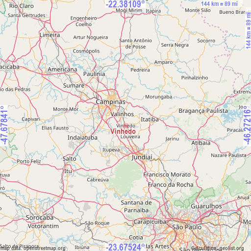
Vinhedo GPS coordinates[2]
23° 1' 46.992" South, 46° 58' 31.008" West
| Map corner | latitude | longitude |
|---|---|---|
| Upper-left | -22.38109°, | -47.67841° |
| Center: | -23.02972°, | -46.97528° |
| Lower-right: | -23.67524°, | -46.27216° |
| Map W x H: | 143.9×143.9 km | = 89.4×89.4mi |
| max Lat: | 2.81972° ⇑78.8% North |
| Vinhedo: | -23.02972° |
| min Lat: | ⇓21.2% South -33.69111° |
| min Long | Vinhedo | max Long |
| -72.89583° | -46.97528° | -32.41083° |
| W 41.6%⇐ | ⇒58.4% E |
Elevation
Elevation of Vinhedo is 733 m = 2405 ft, and this is 352.1 m = 1155 ft above average elevation for this country.
| Max E: |
1603 m = 5259 ft | 17% |
| Vinhedo | 733 m 2405 ft | |
| Avg. | 380.9 m = 1250 ft | |
Min E: |
0 m = 0 ft | 83% |
See also: Vinhedo elevation on elevation.city.
Geographical zone
Vinhedo is located in South Torrid zone (between Equator and Tropic of Capricorn). Distance of this Southern Tropic circle is 45.3 km =28.1 mi to South.| Distance of | km | miles | from Vinhedo |
|---|---|---|---|
| Equator | 2560.7 | 1591.1 | to North |
| Tropic Capricorn | 45.3 | 28.1 | to South |
| Antarctic Circle | 4840.5 | 3007.7 | to South |
| South Pole | 7446.4 | 4627 | to South |


Nearby cities:
15 places around Vinhedo: (largest is in red/bold)
• Cabreúva
34.8 km =21.6 mi,  207°
207°
• Campinas
16.3 km =10.1 mi,  327°
327°
• Campo Limpo Paulista
27.7 km =17.2 mi,  135°
135°
• Hortolândia
31.5 km =19.6 mi,  307°
307°
• Indaiatuba
25.1 km =15.6 mi,  254°
254°
• Itatiba
14.2 km =8.8 mi,  79°
79°
• Itupeva
16.1 km =10 mi, 211°
• Jarinu
26.5 km =16.5 mi,  107°
107°
• Jundiaí
19.8 km =12.3 mi,  151°
151°
• Louveira
6.8 km =4.2 mi,  158°
158°
• Monte Mor
36.1 km =22.4 mi,  284°
284°
• Paulínia
35 km =21.7 mi, 328°
• Pedreira
32.9 km =20.4 mi,  13°
13°
• Valinhos
6.9 km =4.3 mi,  342°
342°
• Várzea Paulista
25.2 km =15.7 mi, 143°
Sources, notices
• [Note1] Compared only with cities in Brazil existing in our database
• [Src1] Map data: © OpenStreetMap contributors (CC-BY-SA)
• [Src2] Other city data from geonames.org with taken over terms of usage.
• [Src3] Geographical zone / Annual Mean Temperature by Robert A. Rohde @ Wikipedia
