Salto geodata
Salto (São Paulo) is a seat of a second-order administrative division; located in Brazil in America/Sao_Paulo (GMT-3) time zone. With population of 98,387 people, there are 237 cities with bigger population in this country. Compared to other cities in Brazil, 80.4% of cities are located further ↑North; 60.1% of cities are located further →East and 68.5% of cities have lower elevation than Salto. Note1


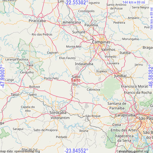
Salto GPS coordinates[2]
23° 12' 2.988" South, 47° 17' 12.984" West
| Map corner | latitude | longitude |
|---|---|---|
| Upper-left | -22.55302°, | -47.99007° |
| Center: | -23.20083°, | -47.28694° |
| Lower-right: | -23.84552°, | -46.58382° |
| Map W x H: | 143.7×143.7 km | = 89.3×89.3mi |
| max Lat: | 2.81972° ⇑80.4% North |
| Salto: | -23.20083° |
| min Lat: | ⇓19.6% South -33.69111° |
| min Long | Salto | max Long |
| -72.89583° | -47.28694° | -32.41083° |
| W 39.9%⇐ | ⇒60.1% E |
Elevation
Elevation of Salto is 562 m = 1844 ft, and this is 181.1 m = 594 ft above average elevation for this country.
| Max E: |
1603 m = 5259 ft | 31.5% |
| Salto | 562 m 1844 ft | |
| Avg. | 380.9 m = 1250 ft | |
Min E: |
0 m = 0 ft | 68.5% |
See also: Salto elevation on elevation.city.
Geographical zone
Salto is located in South Torrid zone (between Equator and Tropic of Capricorn). Distance of this Southern Tropic circle is 26.2 km =16.3 mi to South.| Distance of | km | miles | from Salto |
|---|---|---|---|
| Equator | 2579.7 | 1603 | to North |
| Tropic Capricorn | 26.2 | 16.3 | to South |
| Antarctic Circle | 4821.5 | 2995.9 | to South |
| South Pole | 7427.4 | 4615.2 | to South |


Nearby cities:
15 places around Salto: (largest is in red/bold)
• Cabreúva
19.7 km =12.2 mi,  126°
126°
• Capivari
32.2 km =20 mi,  315°
315°
• Elias Fausto
19.7 km =12.2 mi,  333°
333°
• Hortolândia
38.7 km =24 mi,  10°
10°
• Indaiatuba
14.7 km =9.1 mi,  31°
31°
• Itu
7.2 km =4.5 mi,  190°
190°
• Itupeva
24 km =14.9 mi,  77°
77°
• Louveira
36.7 km =22.8 mi,  69°
69°
• Monte Mor
28.4 km =17.6 mi,  354°
354°
• Pirapora do Bom Jesus
36.3 km =22.6 mi, 126°
• Porto Feliz
24.3 km =15.1 mi,  266°
266°
• Sorocaba
37.7 km =23.4 mi,  207°
207°
• São Roque
39.7 km =24.7 mi,  157°
157°
• Valinhos
39.3 km =24.4 mi,  49°
49°
• Vinhedo
37.1 km =23.1 mi,  59°
59°
Sources, notices
• [Note1] Compared only with cities in Brazil existing in our database
• [Src1] Map data: © OpenStreetMap contributors (CC-BY-SA)
• [Src2] Other city data from geonames.org with taken over terms of usage.
• [Src3] Geographical zone / Annual Mean Temperature by Robert A. Rohde @ Wikipedia
