Itaperuçu geodata
Itaperuçu (Paraná) is a populated place; located in Brazil in America/Sao_Paulo (GMT-3) time zone. With population of 26,546 people, there are 746 cities with bigger population in this country. Compared to other cities in Brazil, 88% of cities are located further ↑North; 74.4% of cities are located further →East and 98% of cities have lower elevation than Itaperuçu. Note1


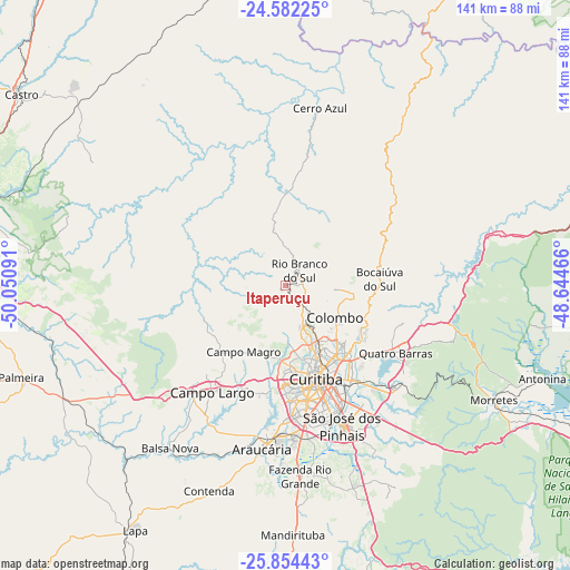
Itaperuçu GPS coordinates[2]
25° 13' 12" South, 49° 20' 52.008" West
| Map corner | latitude | longitude |
|---|---|---|
| Upper-left | -24.58225°, | -50.05091° |
| Center: | -25.22°, | -49.34778° |
| Lower-right: | -25.85443°, | -48.64466° |
| Map W x H: | 141.5×141.5 km | = 87.9×87.9mi |
| max Lat: | 2.81972° ⇑88% North |
| Itaperuçu: | -25.22° |
| min Lat: | ⇓12% South -33.69111° |
| min Long | Itaperuçu | max Long |
| -72.89583° | -49.34778° | -32.41083° |
| W 25.6%⇐ | ⇒74.4% E |
Elevation
Elevation of Itaperuçu is 978 m = 3209 ft, and this is 597.1 m = 1959 ft above average elevation for this country.
| Max E: |
1603 m = 5259 ft | 2% |
| Itaperuçu | 978 m 3209 ft | |
| Avg. | 380.9 m = 1250 ft | |
Min E: |
0 m = 0 ft | 98% |
See also: Brazil elevation on elevation.city.
Geographical zone
Itaperuçu is located in South temperate zone (between Tropic of Capricorn and the Antarctic Circle). Distance of this Southern Tropic circle is 198.3 km =123.2 mi to North.| Distance of | km | miles | from Itaperuçu |
|---|---|---|---|
| Equator | 2804.2 | 1742.4 | to North |
| Tropic Capricorn | 198.3 | 123.2 | to North |
| Antarctic Circle | 4597 | 2856.4 | to South |
| South Pole | 7202.9 | 4475.7 | to South |


Nearby cities:
15 places around Itaperuçu: (largest is in red/bold)
• Almirante Tamandaré
12.2 km =7.6 mi,  161°
161°
• Antonina
68 km =42.3 mi,  109°
109°
• Araucária
42 km =26.1 mi,  188°
188°
• Campina Grande do Sul
30.9 km =19.2 mi, 107°
• Campo Largo
32.3 km =20.1 mi,  214°
214°
• Castro
82.3 km =51.1 mi,  305°
305°
• Colombo
14.8 km =9.2 mi,  122°
122°
• Curitiba
24.3 km =15.1 mi, 161°
• Lapa
71.4 km =44.4 mi, 211°
• Palmeira
70.2 km =43.6 mi,  250°
250°
• Pinhais
29.5 km =18.3 mi,  148°
148°
• Piraquara
37.4 km =23.2 mi,  131°
131°
• Quatro Barras
31.7 km =19.7 mi, 120°
• Rio Branco do Sul
4.7 km =2.9 mi,  45°
45°
• São José dos Pinhais
37.2 km =23.1 mi, 157°
Sources, notices
• [Note1] Compared only with cities in Brazil existing in our database
• [Src1] Map data: © OpenStreetMap contributors (CC-BY-SA)
• [Src2] Other city data from geonames.org with taken over terms of usage.
• [Src3] Geographical zone / Annual Mean Temperature by Robert A. Rohde @ Wikipedia
