Lapa geodata
Lapa (Paraná) is a populated place; located in Brazil in America/Sao_Paulo (GMT-3) time zone. With population of 25,621 people, there are 768 cities with bigger population in this country. Compared to other cities in Brazil, 89.3% of cities are located further ↑North; 77% of cities are located further →East and 96.6% of cities have lower elevation than Lapa. Note1


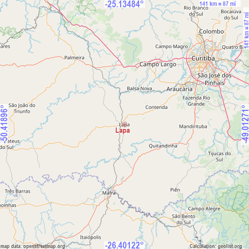
Lapa GPS coordinates[2]
25° 46' 10.992" South, 49° 42' 56.988" West
| Map corner | latitude | longitude |
|---|---|---|
| Upper-left | -25.13484°, | -50.41896° |
| Center: | -25.76972°, | -49.71583° |
| Lower-right: | -26.40122°, | -49.01271° |
| Map W x H: | 140.8×140.8 km | = 87.5×87.5mi |
| max Lat: | 2.81972° ⇑89.3% North |
| Lapa: | -25.76972° |
| min Lat: | ⇓10.7% South -33.69111° |
| min Long | Lapa | max Long |
| -72.89583° | -49.71583° | -32.41083° |
| W 23%⇐ | ⇒77% E |
Elevation
Elevation of Lapa is 929 m = 3048 ft, and this is 548.1 m = 1798 ft above average elevation for this country.
| Max E: |
1603 m = 5259 ft | 3.4% |
| Lapa | 929 m 3048 ft | |
| Avg. | 380.9 m = 1250 ft | |
Min E: |
0 m = 0 ft | 96.6% |
See also: Brazil elevation on elevation.city.
Geographical zone
Lapa is located in South temperate zone (between Tropic of Capricorn and the Antarctic Circle). Distance of this Southern Tropic circle is 259.4 km =161.2 mi to North.| Distance of | km | miles | from Lapa |
|---|---|---|---|
| Equator | 2865.3 | 1780.4 | to North |
| Tropic Capricorn | 259.4 | 161.2 | to North |
| Antarctic Circle | 4535.8 | 2818.4 | to South |
| South Pole | 7141.7 | 4437.6 | to South |


Nearby cities:
15 places around Lapa: (largest is in red/bold)
• Almirante Tamandaré
64.1 km =39.8 mi,  39°
39°
• Araucária
36.4 km =22.6 mi,  57°
57°
• Campo Largo
39.2 km =24.4 mi,  28°
28°
• Colombo
72.5 km =45 mi, 42°
• Curitiba
58.5 km =36.4 mi,  49°
49°
• Itaperuçu
71.4 km =44.4 mi, 31°
• Mafra
39 km =24.2 mi,  193°
193°
• Palmeira
47.8 km =29.7 mi,  322°
322°
• Pinhais
63.7 km =39.6 mi, 55°
• Rio Negrinho
57.4 km =35.7 mi,  159°
159°
• Rio Negro
38.3 km =23.8 mi, 192°
• São Bento do Sul
63.2 km =39.3 mi,  147°
147°
• São José dos Pinhais
57.4 km =35.7 mi, 62°
• São Mateus do Sul
67.8 km =42.1 mi,  260°
260°
• Três Barras
71.3 km =44.3 mi,  238°
238°
Sources, notices
• [Note1] Compared only with cities in Brazil existing in our database
• [Src1] Map data: © OpenStreetMap contributors (CC-BY-SA)
• [Src2] Other city data from geonames.org with taken over terms of usage.
• [Src3] Geographical zone / Annual Mean Temperature by Robert A. Rohde @ Wikipedia
