Palmeira geodata
Palmeira (Paraná) is a populated place; located in Brazil in America/Sao_Paulo (GMT-3) time zone. With population of 18,630 people, there are 1002 cities with bigger population in this country. Compared to other cities in Brazil, 88.6% of cities are located further ↑North; 78.2% of cities are located further →East and 95.9% of cities have lower elevation than Palmeira. Note1


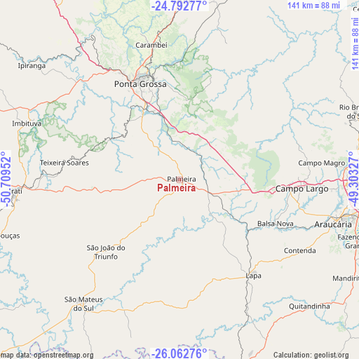
Palmeira GPS coordinates[2]
25° 25' 45.984" South, 50° 0' 23.004" West
| Map corner | latitude | longitude |
|---|---|---|
| Upper-left | -24.79277°, | -50.70952° |
| Center: | -25.42944°, | -50.00639° |
| Lower-right: | -26.06276°, | -49.30327° |
| Map W x H: | 141.2×141.2 km | = 87.7×87.7mi |
| max Lat: | 2.81972° ⇑88.6% North |
| Palmeira: | -25.42944° |
| min Lat: | ⇓11.4% South -33.69111° |
| min Long | Palmeira | max Long |
| -72.89583° | -50.00639° | -32.41083° |
| W 21.8%⇐ | ⇒78.2% E |
Elevation
Elevation of Palmeira is 913 m = 2995 ft, and this is 532.1 m = 1746 ft above average elevation for this country.
| Max E: |
1603 m = 5259 ft | 4.1% |
| Palmeira | 913 m 2995 ft | |
| Avg. | 380.9 m = 1250 ft | |
Min E: |
0 m = 0 ft | 95.9% |
See also: Brazil elevation on elevation.city.
Geographical zone
Palmeira is located in South temperate zone (between Tropic of Capricorn and the Antarctic Circle). Distance of this Southern Tropic circle is 221.6 km =137.7 mi to North.| Distance of | km | miles | from Palmeira |
|---|---|---|---|
| Equator | 2827.5 | 1756.9 | to North |
| Tropic Capricorn | 221.6 | 137.7 | to North |
| Antarctic Circle | 4573.7 | 2842 | to South |
| South Pole | 7179.6 | 4461.2 | to South |


Nearby cities:
15 places around Palmeira: (largest is in red/bold)
• Almirante Tamandaré
70.9 km =44.1 mi,  80°
80°
• Araucária
62.5 km =38.8 mi,  106°
106°
• Campo Largo
47.9 km =29.8 mi,  94°
94°
• Carambeí
54.2 km =33.7 mi,  348°
348°
• Castro
71.2 km =44.2 mi,  359°
359°
• Curitiba
73.6 km =45.7 mi, 89°
• Imbituva
64.1 km =39.8 mi,  290°
290°
• Irati
64.9 km =40.3 mi,  266°
266°
• Itaperuçu
70.2 km =43.6 mi,  70°
70°
• Lapa
47.8 km =29.7 mi,  142°
142°
• Mafra
78.5 km =48.8 mi,  165°
165°
• Ponta Grossa
40.3 km =25 mi,  337°
337°
• Rio Branco do Sul
74.5 km =46.3 mi, 69°
• Rio Negro
78.1 km =48.5 mi,  164°
164°
• São Mateus do Sul
62.2 km =38.6 mi,  217°
217°
Sources, notices
• [Note1] Compared only with cities in Brazil existing in our database
• [Src1] Map data: © OpenStreetMap contributors (CC-BY-SA)
• [Src2] Other city data from geonames.org with taken over terms of usage.
• [Src3] Geographical zone / Annual Mean Temperature by Robert A. Rohde @ Wikipedia
