Castro geodata
Castro (Paraná) is a populated place; located in Brazil in America/Sao_Paulo (GMT-3) time zone. With population of 42,091 people, there are 501 cities with bigger population in this country. Compared to other cities in Brazil, 87.6% of cities are located further ↑North; 78.3% of cities are located further →East and 98.1% of cities have lower elevation than Castro. Note1


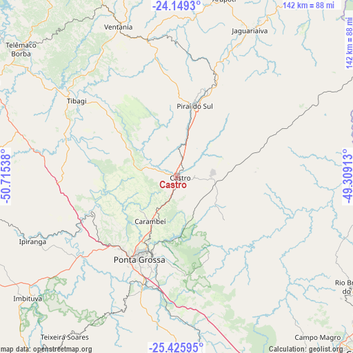
Castro GPS coordinates[2]
24° 47' 21.372" South, 50° 0' 44.1" West
| Map corner | latitude | longitude |
|---|---|---|
| Upper-left | -24.1493°, | -50.71538° |
| Center: | -24.78927°, | -50.01225° |
| Lower-right: | -25.42595°, | -49.30913° |
| Map W x H: | 142×142 km | = 88.2×88.2mi |
| max Lat: | 2.81972° ⇑87.6% North |
| Castro: | -24.78927° |
| min Lat: | ⇓12.4% South -33.69111° |
| min Long | Castro | max Long |
| -72.89583° | -50.01225° | -32.41083° |
| W 21.7%⇐ | ⇒78.3% E |
Elevation
Elevation of Castro is 986 m = 3235 ft, and this is 605.1 m = 1985 ft above average elevation for this country.
| Max E: |
1603 m = 5259 ft | 1.9% |
| Castro | 986 m 3235 ft | |
| Avg. | 380.9 m = 1250 ft | |
Min E: |
0 m = 0 ft | 98.1% |
See also: Castro elevation on elevation.city.
Geographical zone
Castro is located in South temperate zone (between Tropic of Capricorn and the Antarctic Circle). Distance of this Southern Tropic circle is 150.4 km =93.5 mi to North.| Distance of | km | miles | from Castro |
|---|---|---|---|
| Equator | 2756.3 | 1712.7 | to North |
| Tropic Capricorn | 150.4 | 93.5 | to North |
| Antarctic Circle | 4644.9 | 2886.2 | to South |
| South Pole | 7250.8 | 4505.4 | to South |


Nearby cities:
15 places around Castro: (largest is in red/bold)
• Almirante Tamandaré
92.5 km =57.5 mi,  130°
130°
• Campo Largo
88.9 km =55.2 mi,  146°
146°
• Carambeí
21 km =13 mi,  209°
209°
• Colombo
97.1 km =60.3 mi, 125°
• Imbituva
77.2 km =48 mi,  230°
230°
• Itaperuçu
82.3 km =51.1 mi, 125°
• Jaguariaíva
67.9 km =42.2 mi,  26°
26°
• Palmeira
71.2 km =44.2 mi,  179°
179°
• Piraí do Sul
30 km =18.6 mi,  12°
12°
• Ponta Grossa
37.2 km =23.1 mi,  203°
203°
• Reserva
86.1 km =53.5 mi,  280°
280°
• Rio Branco do Sul
83.3 km =51.8 mi,  122°
122°
• Sengés
93.5 km =58.1 mi,  36°
36°
• Telêmaco Borba
80 km =49.7 mi,  310°
310°
• Tibagi
51.1 km =31.8 mi, 307°
Sources, notices
• [Note1] Compared only with cities in Brazil existing in our database
• [Src1] Map data: © OpenStreetMap contributors (CC-BY-SA)
• [Src2] Other city data from geonames.org with taken over terms of usage.
• [Src3] Geographical zone / Annual Mean Temperature by Robert A. Rohde @ Wikipedia
