Mendes geodata
Mendes (Rio de Janeiro) is a populated place; located in Brazil in America/Sao_Paulo (GMT-3) time zone. With population of 17,308 people, there are 1076 cities with bigger population in this country. Compared to other cities in Brazil, 74% of cities are located further ↑North; 57.3% of cities are located further ←West and 54.9% of cities have lower elevation than Mendes. Note1


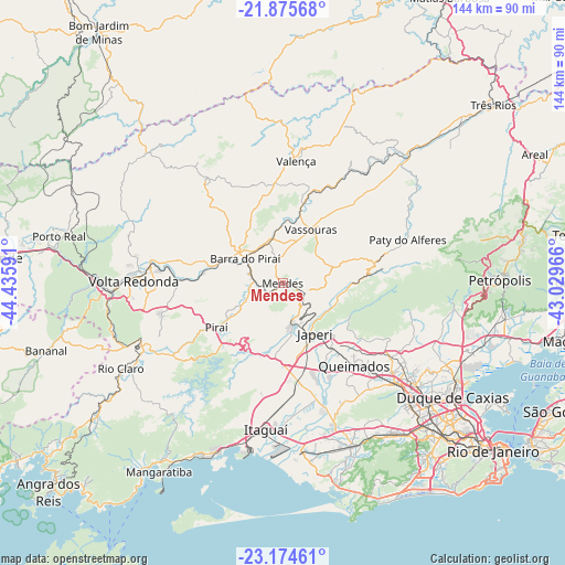
Mendes GPS coordinates[2]
22° 31' 36.012" South, 43° 43' 58.008" West
| Map corner | latitude | longitude |
|---|---|---|
| Upper-left | -21.87568°, | -44.43591° |
| Center: | -22.52667°, | -43.73278° |
| Lower-right: | -23.17461°, | -43.02966° |
| Map W x H: | 144.4×144.4 km | = 89.7×89.7mi |
| max Lat: | 2.81972° ⇑74% North |
| Mendes: | -22.52667° |
| min Lat: | ⇓26% South -33.69111° |
| min Long | Mendes | max Long |
| -72.89583° | -43.73278° | -32.41083° |
| W 57.3%⇐ | ⇒42.7% E |
Elevation
Elevation of Mendes is 419 m = 1375 ft, and this is 38.1 m = 125 ft above average elevation for this country.
| Max E: |
1603 m = 5259 ft | 45.1% |
| Mendes | 419 m 1375 ft | |
| Avg. | 380.9 m = 1250 ft | |
Min E: |
0 m = 0 ft | 54.9% |
See also: Brazil elevation on elevation.city.
Geographical zone
Mendes is located in South Torrid zone (between Equator and Tropic of Capricorn). Distance of this Southern Tropic circle is 101.2 km =62.9 mi to South.| Distance of | km | miles | from Mendes |
|---|---|---|---|
| Equator | 2504.7 | 1556.3 | to North |
| Tropic Capricorn | 101.2 | 62.9 | to South |
| Antarctic Circle | 4896.4 | 3042.5 | to South |
| South Pole | 7502.3 | 4661.7 | to South |


Nearby cities:
15 places around Mendes: (largest is in red/bold)
• Barra do Piraí
11.4 km =7.1 mi,  303°
303°
• Belford Roxo
43.2 km =26.8 mi,  127°
127°
• Itaguaí
36.5 km =22.7 mi,  186°
186°
• Japeri
15.3 km =9.5 mi,  147°
147°
• Miguel Pereira
28.3 km =17.6 mi,  73°
73°
• Nova Iguaçu
38.8 km =24.1 mi, 131°
• Paracambi
9.4 km =5.8 mi,  164°
164°
• Paty do Alferes
34.1 km =21.2 mi, 71°
• Pinheiral
27.5 km =17.1 mi,  273°
273°
• Piraí
20.4 km =12.7 mi,  236°
236°
• Queimados
27.8 km =17.3 mi,  139°
139°
• Seropédica
24.3 km =15.1 mi,  173°
173°
• Valença
31.4 km =19.5 mi,  6°
6°
• Vassouras
15.4 km =9.6 mi,  27°
27°
• Volta Redonda
38.1 km =23.7 mi, 270°
Sources, notices
• [Note1] Compared only with cities in Brazil existing in our database
• [Src1] Map data: © OpenStreetMap contributors (CC-BY-SA)
• [Src2] Other city data from geonames.org with taken over terms of usage.
• [Src3] Geographical zone / Annual Mean Temperature by Robert A. Rohde @ Wikipedia
