Imbituba geodata
Imbituba (Santa Catarina) is a populated place; located in Brazil in America/Sao_Paulo (GMT-3) time zone. With population of 43,450 people, there are 491 cities with bigger population in this country. Compared to other cities in Brazil, 94.3% of cities are located further ↑North; 69.3% of cities are located further →East and 87.8% of cities have higher elevation than Imbituba. Note1


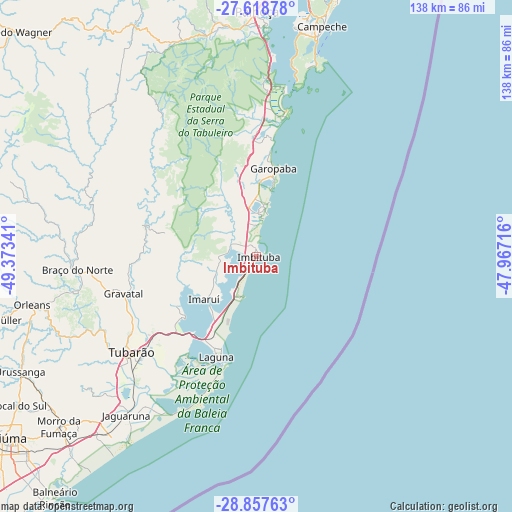
Imbituba GPS coordinates[2]
28° 14' 24" South, 48° 40' 13.008" West
| Map corner | latitude | longitude |
|---|---|---|
| Upper-left | -27.61878°, | -49.37341° |
| Center: | -28.24°, | -48.67028° |
| Lower-right: | -28.85763°, | -47.96716° |
| Map W x H: | 137.7×137.7 km | = 85.6×85.6mi |
| max Lat: | 2.81972° ⇑94.3% North |
| Imbituba: | -28.24° |
| min Lat: | ⇓5.7% South -33.69111° |
| min Long | Imbituba | max Long |
| -72.89583° | -48.67028° | -32.41083° |
| W 30.7%⇐ | ⇒69.3% E |
Elevation
Elevation of Imbituba is 22 m = 72 ft, and this is 358.9 m = 1177 ft below average elevation for this country.
| Max E: |
1603 m = 5259 ft | 87.8% |
| Avg. | 380.9 m = 1250 ft | |
| Imbituba | 22 m = 72 ft | |
Min E: |
0 m = 0 ft | 12.2% |
See also: Imbituba elevation on elevation.city.
Geographical zone
Imbituba is located in South temperate zone (between Tropic of Capricorn and the Antarctic Circle). Distance of this Southern Tropic circle is 534.1 km =331.9 mi to North.| Distance of | km | miles | from Imbituba |
|---|---|---|---|
| Equator | 3140 | 1951.1 | to North |
| Tropic Capricorn | 534.1 | 331.9 | to North |
| Antarctic Circle | 4261.2 | 2647.8 | to South |
| South Pole | 6867.1 | 4267 | to South |


Nearby cities:
15 places around Imbituba: (largest is in red/bold)
• Acores
52.9 km =32.9 mi,  15°
15°
• Anitápolis
58.6 km =36.4 mi,  309°
309°
• Armação
56.8 km =35.3 mi, 16°
• Braço do Norte
48.7 km =30.3 mi,  265°
265°
• Caiacanga da Barra do Sul
53.9 km =33.5 mi,  10°
10°
• Freguesia do Ribeirao da Ilha
59 km =36.7 mi, 10°
• Jaguaruna
54.8 km =34.1 mi,  219°
219°
• Laguna
29.1 km =18.1 mi,  201°
201°
• Orleans
62.2 km =38.6 mi,  257°
257°
• Pantano do Sul
53.6 km =33.3 mi, 17°
• Ribeirão da Ilha
61.6 km =38.3 mi, 12°
• Santo Amaro da Imperatriz
62.3 km =38.7 mi,  350°
350°
• São José
48.4 km =30.1 mi, 273°
• Tapera
62.8 km =39 mi, 10°
• Tubarão
41.5 km =25.8 mi,  232°
232°
Sources, notices
• [Note1] Compared only with cities in Brazil existing in our database
• [Src1] Map data: © OpenStreetMap contributors (CC-BY-SA)
• [Src2] Other city data from geonames.org with taken over terms of usage.
• [Src3] Geographical zone / Annual Mean Temperature by Robert A. Rohde @ Wikipedia
