Belo Horizonte geodata
Belo Horizonte (Minas Gerais) is a seat of a first-order administrative division; located in Brazil in America/Sao_Paulo (GMT-3) time zone. With population of 2,373,224 people, there are 4 cities with bigger population in this country. Compared to other cities in Brazil, 56.5% of cities are located further ↑North; 56.1% of cities are located further ←West and 93.5% of cities have lower elevation than Belo Horizonte. Note1


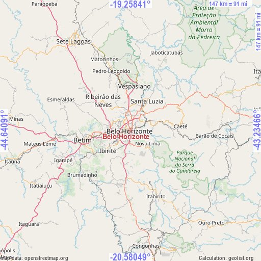
Belo Horizonte GPS coordinates[2]
19° 55' 14.988" South, 43° 56' 16.008" West
| Map corner | latitude | longitude |
|---|---|---|
| Upper-left | -19.25841°, | -44.64091° |
| Center: | -19.92083°, | -43.93778° |
| Lower-right: | -20.58049°, | -43.23466° |
| Map W x H: | 147×147 km | = 91.3×91.3mi |
| max Lat: | 2.81972° ⇑56.5% North |
| Belo Horizonte: | -19.92083° |
| min Lat: | ⇓43.5% South -33.69111° |
| min Long | Belo Horizonte | max Long |
| -72.89583° | -43.93778° | -32.41083° |
| W 56.1%⇐ | ⇒43.9% E |
Elevation
Elevation of Belo Horizonte is 872 m = 2861 ft, and this is 491.1 m = 1611 ft above average elevation for this country.
| Max E: |
1603 m = 5259 ft | 6.5% |
| Belo Horizonte | 872 m 2861 ft | |
| Avg. | 380.9 m = 1250 ft | |
Min E: |
0 m = 0 ft | 93.5% |
See also: Belo Horizonte elevation on elevation.city.
Geographical zone
Belo Horizonte is located in South Torrid zone (between Equator and Tropic of Capricorn). Distance of this Southern Tropic circle is 390.9 km =242.9 mi to South.| Distance of | km | miles | from Belo Horizonte |
|---|---|---|---|
| Equator | 2215 | 1376.3 | to North |
| Tropic Capricorn | 390.9 | 242.9 | to South |
| Antarctic Circle | 5186.2 | 3222.6 | to South |
| South Pole | 7792.1 | 4841.8 | to South |


Nearby cities:
15 places around Belo Horizonte: (largest is in red/bold)
• Betim
27.7 km =17.2 mi,  259°
259°
• Brumadinho
36.9 km =22.9 mi,  227°
227°
• Caeté
28.4 km =17.6 mi,  80°
80°
• Contagem
12.2 km =7.6 mi, 264°
• Ibirité
16.9 km =10.5 mi, 228°
• Itabirito
39.6 km =24.6 mi,  158°
158°
• Lagoa Santa
32.6 km =20.3 mi,  6°
6°
• Nova Lima
11.9 km =7.4 mi,  127°
127°
• Pedro Leopoldo
35.4 km =22 mi,  341°
341°
• Raposos
14.9 km =9.3 mi,  110°
110°
• Ribeirão das Neves
23.1 km =14.4 mi,  317°
317°
• Santa Luzia
19.1 km =11.9 mi,  28°
28°
• Sarzedo
25.1 km =15.6 mi,  239°
239°
• São Joaquim de Bicas
37.9 km =23.5 mi,  247°
247°
• Vespasiano
25.5 km =15.8 mi,  3°
3°
Sources, notices
• [Note1] Compared only with cities in Brazil existing in our database
• [Src1] Map data: © OpenStreetMap contributors (CC-BY-SA)
• [Src2] Other city data from geonames.org with taken over terms of usage.
• [Src3] Geographical zone / Annual Mean Temperature by Robert A. Rohde @ Wikipedia
