Vespasiano geodata
Vespasiano (Minas Gerais) is a populated place; located in Brazil in America/Sao_Paulo (GMT-3) time zone. With population of 94,749 people, there are 246 cities with bigger population in this country. Compared to other cities in Brazil, 55.3% of cities are located further ↑North; 56.2% of cities are located further ←West and 80.1% of cities have lower elevation than Vespasiano. Note1


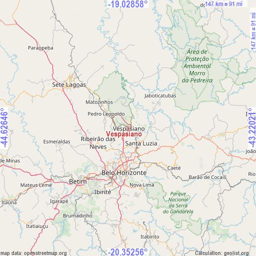
Vespasiano GPS coordinates[2]
19° 41' 30.984" South, 43° 55' 23.988" West
| Map corner | latitude | longitude |
|---|---|---|
| Upper-left | -19.02858°, | -44.62646° |
| Center: | -19.69194°, | -43.92333° |
| Lower-right: | -20.35256°, | -43.22021° |
| Map W x H: | 147.2×147.2 km | = 91.5×91.5mi |
| max Lat: | 2.81972° ⇑55.3% North |
| Vespasiano: | -19.69194° |
| min Lat: | ⇓44.7% South -33.69111° |
| min Long | Vespasiano | max Long |
| -72.89583° | -43.92333° | -32.41083° |
| W 56.2%⇐ | ⇒43.8% E |
Elevation
Elevation of Vespasiano is 689 m = 2260 ft, and this is 308.1 m = 1011 ft above average elevation for this country.
| Max E: |
1603 m = 5259 ft | 19.9% |
| Vespasiano | 689 m 2260 ft | |
| Avg. | 380.9 m = 1250 ft | |
Min E: |
0 m = 0 ft | 80.1% |
See also: Vespasiano elevation on elevation.city.
Geographical zone
Vespasiano is located in South Torrid zone (between Equator and Tropic of Capricorn). Distance of this Southern Tropic circle is 416.4 km =258.7 mi to South.| Distance of | km | miles | from Vespasiano |
|---|---|---|---|
| Equator | 2189.5 | 1360.5 | to North |
| Tropic Capricorn | 416.4 | 258.7 | to South |
| Antarctic Circle | 5211.6 | 3238.3 | to South |
| South Pole | 7817.5 | 4857.6 | to South |


Nearby cities:
15 places around Vespasiano: (largest is in red/bold)
• Belo Horizonte
25.5 km =15.8 mi,  183°
183°
• Betim
42 km =26.1 mi,  223°
223°
• Caeté
33.8 km =21 mi,  128°
128°
• Contagem
29.9 km =18.6 mi,  207°
207°
• Esmeraldas
41.6 km =25.8 mi,  259°
259°
• Ibirité
39.3 km =24.4 mi,  201°
201°
• Lagoa Santa
7.3 km =4.5 mi,  18°
18°
• Matozinhos
22.3 km =13.9 mi,  312°
312°
• Nova Lima
33.6 km =20.9 mi,  166°
166°
• Pedro Leopoldo
15 km =9.3 mi,  303°
303°
• Raposos
33 km =20.5 mi,  157°
157°
• Ribeirão das Neves
19 km =11.8 mi,  243°
243°
• Santa Luzia
11.5 km =7.1 mi,  138°
138°
• Sarzedo
44.6 km =27.7 mi, 211°
• Sete Lagoas
42.2 km =26.2 mi, 306°
Sources, notices
• [Note1] Compared only with cities in Brazil existing in our database
• [Src1] Map data: © OpenStreetMap contributors (CC-BY-SA)
• [Src2] Other city data from geonames.org with taken over terms of usage.
• [Src3] Geographical zone / Annual Mean Temperature by Robert A. Rohde @ Wikipedia
