Pedro Leopoldo geodata
Pedro Leopoldo (Minas Gerais) is a populated place; located in Brazil in America/Sao_Paulo (GMT-3) time zone. With population of 49,261 people, there are 432 cities with bigger population in this country. Compared to other cities in Brazil, 55% of cities are located further ↑North; 55.7% of cities are located further ←West and 81.7% of cities have lower elevation than Pedro Leopoldo. Note1


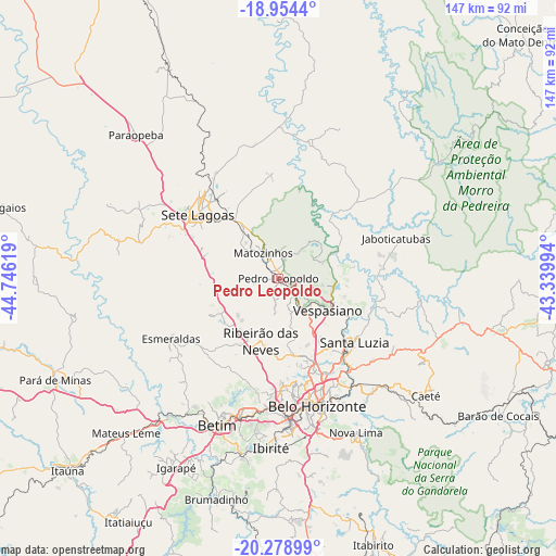
Pedro Leopoldo GPS coordinates[2]
19° 37' 5.016" South, 44° 2' 35.016" West
| Map corner | latitude | longitude |
|---|---|---|
| Upper-left | -18.9544°, | -44.74619° |
| Center: | -19.61806°, | -44.04306° |
| Lower-right: | -20.27899°, | -43.33994° |
| Map W x H: | 147.3×147.3 km | = 91.5×91.5mi |
| max Lat: | 2.81972° ⇑55% North |
| Pedro Leopoldo: | -19.61806° |
| min Lat: | ⇓45% South -33.69111° |
| min Long | Pedro Leopoldo | max Long |
| -72.89583° | -44.04306° | -32.41083° |
| W 55.7%⇐ | ⇒44.3% E |
Elevation
Elevation of Pedro Leopoldo is 714 m = 2343 ft, and this is 333.1 m = 1093 ft above average elevation for this country.
| Max E: |
1603 m = 5259 ft | 18.3% |
| Pedro Leopoldo | 714 m 2343 ft | |
| Avg. | 380.9 m = 1250 ft | |
Min E: |
0 m = 0 ft | 81.7% |
See also: Pedro Leopoldo elevation on elevation.city.
Geographical zone
Pedro Leopoldo is located in South Torrid zone (between Equator and Tropic of Capricorn). Distance of this Southern Tropic circle is 424.6 km =263.8 mi to South.| Distance of | km | miles | from Pedro Leopoldo |
|---|---|---|---|
| Equator | 2181.3 | 1355.4 | to North |
| Tropic Capricorn | 424.6 | 263.8 | to South |
| Antarctic Circle | 5219.9 | 3243.5 | to South |
| South Pole | 7825.7 | 4862.7 | to South |


Nearby cities:
15 places around Pedro Leopoldo: (largest is in red/bold)
• Belo Horizonte
35.4 km =22 mi,  161°
161°
• Betim
42.1 km =26.2 mi,  202°
202°
• Contagem
34.9 km =21.7 mi,  181°
181°
• Esmeraldas
32.6 km =20.3 mi,  240°
240°
• Ibirité
44.9 km =27.9 mi, 182°
• Juatuba
48.6 km =30.2 mi,  220°
220°
• Lagoa Santa
14.9 km =9.3 mi,  95°
95°
• Matozinhos
7.8 km =4.8 mi,  329°
329°
• Nova Lima
45.7 km =28.4 mi,  153°
153°
• Raposos
46.2 km =28.7 mi, 147°
• Ribeirão das Neves
17.2 km =10.7 mi, 195°
• Santa Luzia
26.2 km =16.3 mi,  130°
130°
• Sarzedo
47.6 km =29.6 mi,  192°
192°
• Sete Lagoas
27.2 km =16.9 mi,  308°
308°
• Vespasiano
15 km =9.3 mi,  123°
123°
Sources, notices
• [Note1] Compared only with cities in Brazil existing in our database
• [Src1] Map data: © OpenStreetMap contributors (CC-BY-SA)
• [Src2] Other city data from geonames.org with taken over terms of usage.
• [Src3] Geographical zone / Annual Mean Temperature by Robert A. Rohde @ Wikipedia
