Bebedouro geodata
Bebedouro (São Paulo) is a populated place; located in Brazil in America/Sao_Paulo (GMT-3) time zone. With population of 71,862 people, there are 318 cities with bigger population in this country. Compared to other cities in Brazil, 62.7% of cities are located further ↑North; 66.9% of cities are located further →East and 70.1% of cities have lower elevation than Bebedouro. Note1


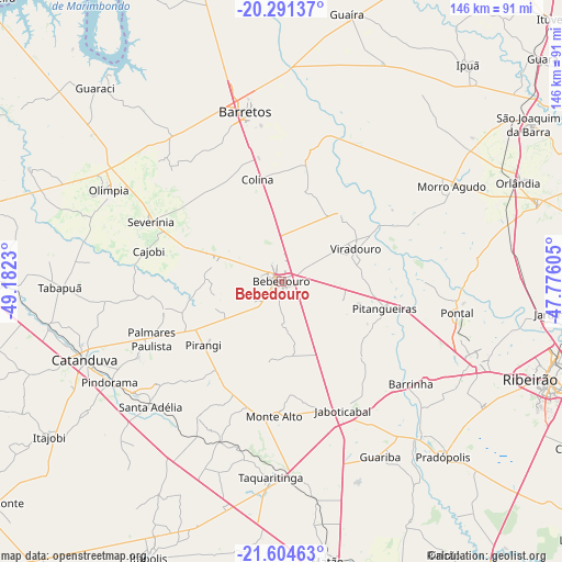
Bebedouro GPS coordinates[2]
20° 56' 57.984" South, 48° 28' 45.012" West
| Map corner | latitude | longitude |
|---|---|---|
| Upper-left | -20.29137°, | -49.1823° |
| Center: | -20.94944°, | -48.47917° |
| Lower-right: | -21.60463°, | -47.77605° |
| Map W x H: | 146×146 km | = 90.7×90.7mi |
| max Lat: | 2.81972° ⇑62.7% North |
| Bebedouro: | -20.94944° |
| min Lat: | ⇓37.3% South -33.69111° |
| min Long | Bebedouro | max Long |
| -72.89583° | -48.47917° | -32.41083° |
| W 33.1%⇐ | ⇒66.9% E |
Elevation
Elevation of Bebedouro is 574 m = 1883 ft, and this is 193.1 m = 634 ft above average elevation for this country.
| Max E: |
1603 m = 5259 ft | 29.9% |
| Bebedouro | 574 m 1883 ft | |
| Avg. | 380.9 m = 1250 ft | |
Min E: |
0 m = 0 ft | 70.1% |
See also: Bebedouro elevation on elevation.city.
Geographical zone
Bebedouro is located in South Torrid zone (between Equator and Tropic of Capricorn). Distance of this Southern Tropic circle is 276.6 km =171.9 mi to South.| Distance of | km | miles | from Bebedouro |
|---|---|---|---|
| Equator | 2329.4 | 1447.4 | to North |
| Tropic Capricorn | 276.6 | 171.9 | to South |
| Antarctic Circle | 5071.8 | 3151.5 | to South |
| South Pole | 7677.7 | 4770.7 | to South |


Nearby cities:
15 places around Bebedouro: (largest is in red/bold)
• Barretos
44.6 km =27.7 mi,  348°
348°
• Barrinha
42.5 km =26.4 mi,  129°
129°
• Jaboticabal
37.6 km =23.4 mi,  154°
154°
• Monte Alto
34.7 km =21.6 mi,  182°
182°
• Monte Azul Paulista
17.5 km =10.9 mi,  285°
285°
• Morro Agudo
50.1 km =31.1 mi,  61°
61°
• Olímpia
51 km =31.7 mi,  297°
297°
• Paraíso
31.5 km =19.6 mi,  256°
256°
• Pindorama
51.6 km =32.1 mi,  239°
239°
• Pitangueiras
27.6 km =17.1 mi,  104°
104°
• Pontal
46.6 km =29 mi, 100°
• Santa Adélia
46.9 km =29.1 mi,  225°
225°
• Severínia
37 km =23 mi, 294°
• Taquaritinga
50.8 km =31.6 mi, 182°
• Viradouro
20.7 km =12.9 mi,  65°
65°
Sources, notices
• [Note1] Compared only with cities in Brazil existing in our database
• [Src1] Map data: © OpenStreetMap contributors (CC-BY-SA)
• [Src2] Other city data from geonames.org with taken over terms of usage.
• [Src3] Geographical zone / Annual Mean Temperature by Robert A. Rohde @ Wikipedia
