Pontal geodata
Pontal (São Paulo) is a populated place; located in Brazil in America/Sao_Paulo (GMT-3) time zone. With population of 32,566 people, there are 628 cities with bigger population in this country. Compared to other cities in Brazil, 63.2% of cities are located further ↑North; 64.8% of cities are located further →East and 65.9% of cities have lower elevation than Pontal. Note1


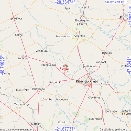
Pontal GPS coordinates[2]
21° 1' 21" South, 48° 2' 13.992" West
| Map corner | latitude | longitude |
|---|---|---|
| Upper-left | -20.36474°, | -48.74035° |
| Center: | -21.0225°, | -48.03722° |
| Lower-right: | -21.67737°, | -47.3341° |
| Map W x H: | 146×146 km | = 90.7×90.7mi |
| max Lat: | 2.81972° ⇑63.2% North |
| Pontal: | -21.0225° |
| min Lat: | ⇓36.8% South -33.69111° |
| min Long | Pontal | max Long |
| -72.89583° | -48.03722° | -32.41083° |
| W 35.2%⇐ | ⇒64.8% E |
Elevation
Elevation of Pontal is 531 m = 1742 ft, and this is 150.1 m = 492 ft above average elevation for this country.
| Max E: |
1603 m = 5259 ft | 34.1% |
| Pontal | 531 m 1742 ft | |
| Avg. | 380.9 m = 1250 ft | |
Min E: |
0 m = 0 ft | 65.9% |
See also: Brazil elevation on elevation.city.
Geographical zone
Pontal is located in South Torrid zone (between Equator and Tropic of Capricorn). Distance of this Southern Tropic circle is 268.4 km =166.8 mi to South.| Distance of | km | miles | from Pontal |
|---|---|---|---|
| Equator | 2337.5 | 1452.5 | to North |
| Tropic Capricorn | 268.4 | 166.8 | to South |
| Antarctic Circle | 5063.7 | 3146.4 | to South |
| South Pole | 7669.6 | 4765.7 | to South |


Nearby cities:
15 places around Pontal: (largest is in red/bold)
• Barrinha
23.1 km =14.4 mi,  214°
214°
• Bebedouro
46.6 km =29 mi,  280°
280°
• Brodósqui
39.5 km =24.5 mi,  84°
84°
• Cravinhos
47.6 km =29.6 mi,  137°
137°
• Guariba
42.4 km =26.3 mi, 207°
• Jaboticabal
39.2 km =24.4 mi,  228°
228°
• Jardinópolis
28.4 km =17.6 mi,  88°
88°
• Morro Agudo
32.4 km =20.1 mi,  356°
356°
• Nuporanga
43.9 km =27.3 mi,  42°
42°
• Orlândia
37.1 km =23.1 mi,  24°
24°
• Pitangueiras
19.2 km =11.9 mi,  274°
274°
• Pradópolis
37.6 km =23.4 mi,  184°
184°
• Ribeirão Preto
29.2 km =18.1 mi,  126°
126°
• Sertãozinho
13.7 km =8.5 mi,  159°
159°
• Viradouro
31.7 km =19.7 mi,  301°
301°
Sources, notices
• [Note1] Compared only with cities in Brazil existing in our database
• [Src1] Map data: © OpenStreetMap contributors (CC-BY-SA)
• [Src2] Other city data from geonames.org with taken over terms of usage.
• [Src3] Geographical zone / Annual Mean Temperature by Robert A. Rohde @ Wikipedia
