Barretos geodata
Barretos (São Paulo) is a populated place; located in Brazil in America/Sao_Paulo (GMT-3) time zone. With population of 101,220 people, there are 223 cities with bigger population in this country. Compared to other cities in Brazil, 60.4% of cities are located further ↑North; 68.4% of cities are located further →East and 66.3% of cities have lower elevation than Barretos. Note1


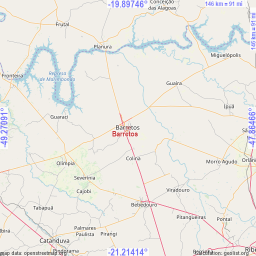
Barretos GPS coordinates[2]
20° 33' 25.992" South, 48° 34' 4.008" West
| Map corner | latitude | longitude |
|---|---|---|
| Upper-left | -19.89746°, | -49.27091° |
| Center: | -20.55722°, | -48.56778° |
| Lower-right: | -21.21414°, | -47.86466° |
| Map W x H: | 146.4×146.4 km | = 91×91mi |
| max Lat: | 2.81972° ⇑60.4% North |
| Barretos: | -20.55722° |
| min Lat: | ⇓39.6% South -33.69111° |
| min Long | Barretos | max Long |
| -72.89583° | -48.56778° | -32.41083° |
| W 31.6%⇐ | ⇒68.4% E |
Elevation
Elevation of Barretos is 538 m = 1765 ft, and this is 157.1 m = 515 ft above average elevation for this country.
| Max E: |
1603 m = 5259 ft | 33.7% |
| Barretos | 538 m 1765 ft | |
| Avg. | 380.9 m = 1250 ft | |
Min E: |
0 m = 0 ft | 66.3% |
See also: Barretos elevation on elevation.city.
Geographical zone
Barretos is located in South Torrid zone (between Equator and Tropic of Capricorn). Distance of this Southern Tropic circle is 320.2 km =199 mi to South.| Distance of | km | miles | from Barretos |
|---|---|---|---|
| Equator | 2285.7 | 1420.3 | to North |
| Tropic Capricorn | 320.2 | 199 | to South |
| Antarctic Circle | 5115.4 | 3178.6 | to South |
| South Pole | 7721.3 | 4797.8 | to South |


Nearby cities:
15 places around Barretos: (largest is in red/bold)
• Bebedouro
44.6 km =27.7 mi,  168°
168°
• Conceição das Alagoas
73.9 km =45.9 mi,  14°
14°
• Frutal
70.8 km =44 mi,  326°
326°
• Guapiaçu
72.8 km =45.2 mi,  248°
248°
• Guaíra
37.7 km =23.4 mi,  45°
45°
• Ipuã
59.4 km =36.9 mi,  77°
77°
• Miguelópolis
69.9 km =43.4 mi, 53°
• Monte Azul Paulista
39.7 km =24.7 mi,  191°
191°
• Morro Agudo
56.5 km =35.1 mi,  110°
110°
• Olímpia
41.3 km =25.7 mi,  240°
240°
• Orlândia
73.2 km =45.5 mi,  104°
104°
• Paraíso
55.4 km =34.4 mi,  202°
202°
• Pitangueiras
61.8 km =38.4 mi,  144°
144°
• Severínia
37.2 km =23.1 mi,  221°
221°
• Viradouro
45 km =28 mi, 141°
Sources, notices
• [Note1] Compared only with cities in Brazil existing in our database
• [Src1] Map data: © OpenStreetMap contributors (CC-BY-SA)
• [Src2] Other city data from geonames.org with taken over terms of usage.
• [Src3] Geographical zone / Annual Mean Temperature by Robert A. Rohde @ Wikipedia
