Severínia geodata
Severínia (São Paulo) is a populated place; located in Brazil in America/Sao_Paulo (GMT-3) time zone. With population of 13,212 people, there are 1355 cities with bigger population in this country. Compared to other cities in Brazil, 61.9% of cities are located further ↑North; 70.2% of cities are located further →East and 71.6% of cities have lower elevation than Severínia. Note1


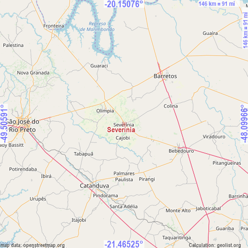
Severínia GPS coordinates[2]
20° 48' 33.984" South, 48° 48' 10.008" West
| Map corner | latitude | longitude |
|---|---|---|
| Upper-left | -20.15076°, | -49.50591° |
| Center: | -20.80944°, | -48.80278° |
| Lower-right: | -21.46525°, | -48.09966° |
| Map W x H: | 146.2×146.2 km | = 90.8×90.8mi |
| max Lat: | 2.81972° ⇑61.9% North |
| Severínia: | -20.80944° |
| min Lat: | ⇓38.1% South -33.69111° |
| min Long | Severínia | max Long |
| -72.89583° | -48.80278° | -32.41083° |
| W 29.8%⇐ | ⇒70.2% E |
Elevation
Elevation of Severínia is 588 m = 1929 ft, and this is 207.1 m = 679 ft above average elevation for this country.
| Max E: |
1603 m = 5259 ft | 28.4% |
| Severínia | 588 m 1929 ft | |
| Avg. | 380.9 m = 1250 ft | |
Min E: |
0 m = 0 ft | 71.6% |
See also: Brazil elevation on elevation.city.
Geographical zone
Severínia is located in South Torrid zone (between Equator and Tropic of Capricorn). Distance of this Southern Tropic circle is 292.1 km =181.5 mi to South.| Distance of | km | miles | from Severínia |
|---|---|---|---|
| Equator | 2313.8 | 1437.7 | to North |
| Tropic Capricorn | 292.1 | 181.5 | to South |
| Antarctic Circle | 5087.4 | 3161.2 | to South |
| South Pole | 7693.3 | 4780.4 | to South |


Nearby cities:
15 places around Severínia: (largest is in red/bold)
• Barretos
37.2 km =23.1 mi,  41°
41°
• Bebedouro
37 km =23 mi,  114°
114°
• Catanduva
40.6 km =25.2 mi,  205°
205°
• Guapiaçu
43.4 km =27 mi,  272°
272°
• Itajobi
62.3 km =38.7 mi,  204°
204°
• Monte Alto
59.4 km =36.9 mi,  147°
147°
• Monte Azul Paulista
20 km =12.4 mi,  122°
122°
• Nova Granada
61.4 km =38.2 mi,  299°
299°
• Olímpia
14.1 km =8.8 mi, 304°
• Paraíso
23.2 km =14.4 mi,  172°
172°
• Pindorama
43.2 km =26.8 mi,  194°
194°
• Pitangueiras
64.3 km =40 mi, 110°
• Santa Adélia
48.2 km =30 mi,  180°
180°
• São José do Rio Preto
59.9 km =37.2 mi, 268°
• Viradouro
53 km =32.9 mi,  97°
97°
Sources, notices
• [Note1] Compared only with cities in Brazil existing in our database
• [Src1] Map data: © OpenStreetMap contributors (CC-BY-SA)
• [Src2] Other city data from geonames.org with taken over terms of usage.
• [Src3] Geographical zone / Annual Mean Temperature by Robert A. Rohde @ Wikipedia
