Xapuri geodata
Xapuri (Acre) is a populated place; located in Brazil in America/Rio_Branco (GMT-5) time zone. With population of 5,721 people, there are 1887 cities with bigger population in this country. Compared to other cities in Brazil, 66.1% of cities are located further ↓South; 99.3% of cities are located further →East and 64.4% of cities have higher elevation than Xapuri. Note1


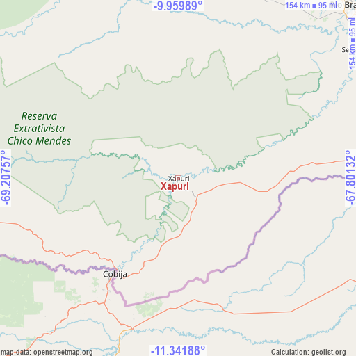
Xapuri GPS coordinates[2]
10° 39' 6.012" South, 68° 30' 15.984" West
| Map corner | latitude | longitude |
|---|---|---|
| Upper-left | -9.95989°, | -69.20757° |
| Center: | -10.65167°, | -68.50444° |
| Lower-right: | -11.34188°, | -67.80132° |
| Map W x H: | 153.7×153.7 km | = 95.5×95.5mi |
| max Lat: | 2.81972° ⇑33.9% North |
| Xapuri: | -10.65167° |
| min Lat: | ⇓66.1% South -33.69111° |
| min Long | Xapuri | max Long |
| -72.89583° | -68.50444° | -32.41083° |
| W 0.7%⇐ | ⇒99.3% E |
Elevation
Elevation of Xapuri is 171 m = 561 ft, and this is 209.9 m = 689 ft below average elevation for this country.
| Max E: |
1603 m = 5259 ft | 64.4% |
| Avg. | 380.9 m = 1250 ft | |
| Xapuri | 171 m = 561 ft | |
Min E: |
0 m = 0 ft | 35.6% |
See also: Brazil elevation on elevation.city.
Geographical zone
Xapuri is located in South Torrid zone (between Equator and Tropic of Capricorn). Distance of Equator is 1184.4 km =736 mi to North.| Distance of | km | miles | from Xapuri |
|---|---|---|---|
| Equator | 1184.4 | 736 | to North |
| Tropic Capricorn | 1421.6 | 883.3 | to South |
| Antarctic Circle | 6216.8 | 3862.9 | to South |
| South Pole | 8822.7 | 5482.2 | to South |


Nearby cities:
13 places around Xapuri: (largest is in red/bold)
• Boca do Acre
243.5 km =151.3 mi,  29°
29°
• Brasiléia
48.5 km =30.1 mi,  213°
213°
• Envira
417.4 km =259.4 mi,  333°
333°
• Extrema
254.7 km =158.3 mi,  67°
67°
• Feijó
343 km =213.1 mi,  323°
323°
• Guajará Mirim
346.5 km =215.3 mi,  92°
92°
• Manoel Urbano
217.9 km =135.4 mi,  337°
337°
• Pauini
367.2 km =228.2 mi, 27°
• Plácido de Castro
148.4 km =92.2 mi,  76°
76°
• Rio Branco
106.9 km =66.4 mi,  45°
45°
• Sena Madureira
177.6 km =110.4 mi,  354°
354°
• Senador Guiomard
100.8 km =62.6 mi,  56°
56°
• Tarauacá
371.7 km =231 mi, 318°
Sources, notices
• [Note1] Compared only with cities in Brazil existing in our database
• [Src1] Map data: © OpenStreetMap contributors (CC-BY-SA)
• [Src2] Other city data from geonames.org with taken over terms of usage.
• [Src3] Geographical zone / Annual Mean Temperature by Robert A. Rohde @ Wikipedia
