Plácido de Castro geodata
Plácido de Castro (Acre) is a populated place; located in Brazil in America/Rio_Branco (GMT-5) time zone. With population of 11,945 people, there are 1480 cities with bigger population in this country. Compared to other cities in Brazil, 67% of cities are located further ↓South; 99% of cities are located further →East and 68.5% of cities have higher elevation than Plácido de Castro. Note1


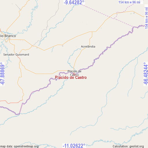
Plácido de Castro GPS coordinates[2]
10° 20' 7.008" South, 67° 11' 8.016" West
| Map corner | latitude | longitude |
|---|---|---|
| Upper-left | -9.64282°, | -67.88869° |
| Center: | -10.33528°, | -67.18556° |
| Lower-right: | -11.02622°, | -66.48244° |
| Map W x H: | 153.8×153.8 km | = 95.6×95.6mi |
| max Lat: | 2.81972° ⇑33% North |
| Plácido de Castro: | -10.33528° |
| min Lat: | ⇓67% South -33.69111° |
| min Long | Plácido de Cas | max Long |
| -72.89583° | -67.18556° | -32.41083° |
| W 1%⇐ | ⇒99% E |
Elevation
Elevation of Plácido de Castro is 136 m = 446 ft, and this is 244.9 m = 803 ft below average elevation for this country.
| Max E: |
1603 m = 5259 ft | 68.5% |
| Avg. | 380.9 m = 1250 ft | |
| Plácido de Castro | 136 m = 446 ft | |
Min E: |
0 m = 0 ft | 31.5% |
See also: Brazil elevation on elevation.city.
Geographical zone
Plácido de Castro is located in South Torrid zone (between Equator and Tropic of Capricorn). Distance of Equator is 1149.2 km =714.1 mi to North.| Distance of | km | miles | from Plácido de Castro |
|---|---|---|---|
| Equator | 1149.2 | 714.1 | to North |
| Tropic Capricorn | 1456.7 | 905.2 | to South |
| Antarctic Circle | 6252 | 3884.8 | to South |
| South Pole | 8857.9 | 5504 | to South |


Nearby cities:
12 places around Plácido de Castro: (largest is in red/bold)
• Boca do Acre
177.6 km =110.4 mi,  352°
352°
• Brasiléia
186.8 km =116.1 mi,  246°
246°
• Extrema
110.4 km =68.6 mi,  55°
55°
• Feijó
423.3 km =263 mi,  304°
304°
• Guajará Mirim
208.3 km =129.4 mi,  103°
103°
• Manoel Urbano
281.8 km =175.1 mi,  306°
306°
• Pauini
292.4 km =181.7 mi,  4°
4°
• Porto Velho
400.1 km =248.6 mi, 64°
• Rio Branco
79.2 km =49.2 mi, 300°
• Sena Madureira
215.8 km =134.1 mi, 310°
• Senador Guiomard
63.8 km =39.6 mi,  288°
288°
• Xapuri
148.4 km =92.2 mi,  256°
256°
Sources, notices
• [Note1] Compared only with cities in Brazil existing in our database
• [Src1] Map data: © OpenStreetMap contributors (CC-BY-SA)
• [Src2] Other city data from geonames.org with taken over terms of usage.
• [Src3] Geographical zone / Annual Mean Temperature by Robert A. Rohde @ Wikipedia
