Ramotswa geodata
Ramotswa (South-East) is a seat of a first-order administrative division; located in Botswana in Africa/Gaborone (GMT+2) time zone. With population of 21,450 people, there are 12 cities with bigger population in this country. Compared to other cities in Botswana, 90.5% of cities are located further ↑North; 51.4% of cities are located further ←West and 61.9% of cities have lower elevation than Ramotswa. Note1


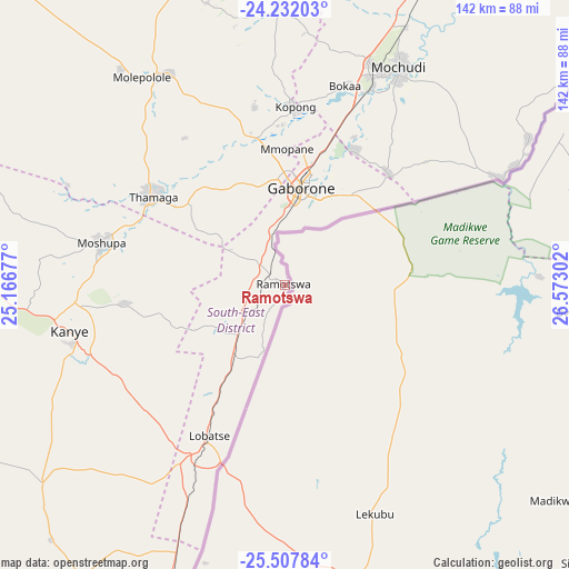
Ramotswa GPS coordinates[2]
24° 52' 17.688" South, 25° 52' 11.604" East
| Map corner | latitude | longitude |
|---|---|---|
| Upper-left | -24.23203°, | 25.16677° |
| Center: | -24.87158°, | 25.86989° |
| Lower-right: | -25.50784°, | 26.57302° |
| Map W x H: | 141.9×141.9 km | = 88.2×88.2mi |
| max Lat: | -17.80165° ⇑90.5% North |
| Ramotswa: | -24.87158° |
| min Lat: | ⇓9.5% South -26.9° |
| min Long | Ramotswa | max Long |
| 20.06667° | 25.86989° | 28.74946° |
| W 51.4%⇐ | ⇒48.6% E |
Elevation
Elevation of Ramotswa is 1039 m = 3409 ft, and this is 24 m = 79 ft above average elevation for this country.
| Max E: |
1406 m = 4613 ft | 38.1% |
| Ramotswa | 1039 m 3409 ft | |
| Avg. | 1015 m = 3330 ft | |
Min E: |
676 m = 2218 ft | 61.9% |
See also: Botswana elevation on elevation.city.
Geographical zone
Ramotswa is located in South temperate zone (between Tropic of Capricorn and the Antarctic Circle). Distance of this Southern Tropic circle is 159.5 km =99.1 mi to North.| Distance of | km | miles | from Ramotswa |
|---|---|---|---|
| Equator | 2765.5 | 1718.4 | to North |
| Tropic Capricorn | 159.5 | 99.1 | to North |
| Antarctic Circle | 4635.7 | 2880.5 | to South |
| South Pole | 7241.6 | 4499.7 | to South |


Nearby cities:
15 places around Ramotswa: (largest is in red/bold)
• Dumadumana
31.6 km =19.6 mi,  0°
0°
• Gabane
24.4 km =15.2 mi,  338°
338°
• Gaborone
24.5 km =15.2 mi,  9°
9°
• Galekgatshwane
39.7 km =24.7 mi,  350°
350°
• Gaphatshwe
33.3 km =20.7 mi, 353°
• Kgaphamadi
37.6 km =23.4 mi, 8°
• Kopong
43.2 km =26.8 mi, 1°
• Metsemotlhaba
36.2 km =22.5 mi, 349°
• Mmokolodi
20.7 km =12.9 mi, 340°
• Mmopone
33.9 km =21.1 mi, 0°
• Mogoditshane
27.2 km =16.9 mi,  359°
359°
• Mononyane
38 km =23.6 mi, 344°
• Nkoyaphiri
26.9 km =16.7 mi, 351°
• Otse
21.2 km =13.2 mi,  220°
220°
• Thamaga
40.2 km =25 mi,  303°
303°
Sources, notices
• [Note1] Compared only with cities in Botswana existing in our database
• [Src1] Map data: © OpenStreetMap contributors (CC-BY-SA)
• [Src2] Other city data from geonames.org with taken over terms of usage.
• [Src3] Geographical zone / Annual Mean Temperature by Robert A. Rohde @ Wikipedia
