Mmokolodi geodata
Mmokolodi (Kweneng) is a populated locality; located in Botswana in Africa/Gaborone (GMT+2) time zone. With population of 647 people, there are 98 cities with bigger population in this country. Compared to other cities in Botswana, 88.6% of cities are located further ↑North; 56.2% of cities are located further →East and 63.8% of cities have lower elevation than Mmokolodi. Note1


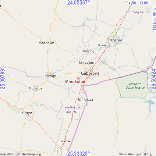
Mmokolodi GPS coordinates[2]
24° 41' 45.996" South, 25° 48' 3.996" East
| Map corner | latitude | longitude |
|---|---|---|
| Upper-left | -24.05567°, | 25.09799° |
| Center: | -24.69611°, | 25.80111° |
| Lower-right: | -25.33328°, | 26.50424° |
| Map W x H: | 142.1×142.1 km | = 88.3×88.3mi |
| max Lat: | -17.80165° ⇑88.6% North |
| Mmokolodi: | -24.69611° |
| min Lat: | ⇓11.4% South -26.9° |
| min Long | Mmokolodi | max Long |
| 20.06667° | 25.80111° | 28.74946° |
| W 43.8%⇐ | ⇒56.2% E |
Elevation
Elevation of Mmokolodi is 1050 m = 3445 ft, and this is 35 m = 115 ft above average elevation for this country.
| Max E: |
1406 m = 4613 ft | 36.2% |
| Mmokolodi | 1050 m 3445 ft | |
| Avg. | 1015 m = 3330 ft | |
Min E: |
676 m = 2218 ft | 63.8% |
See also: Botswana elevation on elevation.city.
Geographical zone
Mmokolodi is located in South temperate zone (between Tropic of Capricorn and the Antarctic Circle). Distance of this Southern Tropic circle is 140 km =87 mi to North.| Distance of | km | miles | from Mmokolodi |
|---|---|---|---|
| Equator | 2746 | 1706.3 | to North |
| Tropic Capricorn | 140 | 87 | to North |
| Antarctic Circle | 4655.2 | 2892.6 | to South |
| South Pole | 7261.1 | 4511.8 | to South |


Nearby cities:
15 places around Mmokolodi: (largest is in red/bold)
• Bokaa
35 km =21.7 mi,  38°
38°
• Dumadumana
14.2 km =8.8 mi,  31°
31°
• Gabane
3.8 km =2.4 mi,  329°
329°
• Gaborone
11.8 km =7.3 mi,  66°
66°
• Galekgatshwane
19.7 km =12.2 mi,  1°
1°
• Gaphatshwe
14 km =8.7 mi,  13°
13°
• Kgaphamadi
21.8 km =13.5 mi, 35°
• Kopong
25.1 km =15.6 mi,  19°
19°
• Metsemotlhaba
16.1 km =10 mi, 0°
• Mmopone
16.1 km =10 mi, 27°
• Mogoditshane
10.1 km =6.3 mi, 40°
• Mononyane
17.4 km =10.8 mi,  350°
350°
• Nkoyaphiri
7.7 km =4.8 mi, 23°
• Ramotswa
20.7 km =12.9 mi,  160°
160°
• Thamaga
26.6 km =16.5 mi,  276°
276°
Sources, notices
• [Note1] Compared only with cities in Botswana existing in our database
• [Src1] Map data: © OpenStreetMap contributors (CC-BY-SA)
• [Src2] Other city data from geonames.org with taken over terms of usage.
• [Src3] Geographical zone / Annual Mean Temperature by Robert A. Rohde @ Wikipedia
