Byarozawka geodata
Byarozawka (Grodnenskaya) is a populated place; located in Belarus in Europe/Minsk (GMT+3) time zone. With population of 11,800 people, there are 67 cities with bigger population in this country. Compared to other cities in Belarus, 52.3% of cities are located further ↑North; 86.5% of cities are located further →East and 82.6% of cities have higher elevation than Byarozawka. Note1


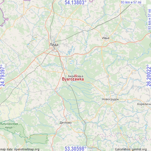
Byarozawka GPS coordinates[2]
53° 43' 26.616" North, 25° 29' 49.524" East
| Map corner | latitude | longitude |
|---|---|---|
| Upper-left | 54.13803°, | 24.79397° |
| Center: | 53.72406°, | 25.49709° |
| Lower-right: | 53.30598°, | 26.20022° |
| Map W x H: | 92.5×92.5 km | = 57.5×57.5mi |
| max Lat: | 56.0147° ⇑52.3% North |
| Byarozawka: | 53.72406° |
| min Lat: | ⇓47.7% South 51.75° |
| min Long | Byarozawka | max Long |
| 23.37083° | 25.49709° | 32.578° |
| W 13.5%⇐ | ⇒86.5% E |
Elevation
Elevation of Byarozawka is 140 m = 459 ft, and this is 28.6 m = 94 ft below average elevation for this country.
| Max E: |
309 m = 1014 ft | 82.6% |
| Avg. | 168.6 m = 553 ft | |
| Byarozawka | 140 m = 459 ft | |
Min E: |
108 m = 354 ft | 17.4% |
See also: Belarus elevation on elevation.city.
Geographical zone
Byarozawka is located in North temperate zone (between Tropic of Cancer and the Arctic Circle). Distance of this North polar circle is 1427.6 km =887.1 mi to North.| Distance of | km | miles | from Byarozawka |
|---|---|---|---|
| North Pole | 4033.5 | 2506.3 | to North |
| Arctic Circle | 1427.6 | 887.1 | to North |
| Tropic Cancer | 3367.6 | 2092.5 | to South |
| Equator | 5973.6 | 3711.8 | to South |


Nearby cities:
15 places around Byarozawka: (largest is in red/bold)
• Byelagruda
23.3 km =14.5 mi,  291°
291°
• Dyatlovo
29.6 km =18.4 mi,  191°
191°
• Haradzishcha
55.9 km =34.7 mi,  142°
142°
• Hyeranyony
43.9 km =27.3 mi,  6°
6°
• Iwye
29.2 km =18.1 mi,  38°
38°
• Karelichy
46 km =28.6 mi,  112°
112°
• Lida
21.9 km =13.6 mi,  323°
323°
• Lyubcha
37.2 km =23.1 mi,  85°
85°
• Novogrudok
25.7 km =16 mi,  124°
124°
• Shchorsy
46.4 km =28.8 mi,  102°
102°
• Shchuchyn
51.3 km =31.9 mi,  254°
254°
• Traby
55.3 km =34.4 mi,  29°
29°
• Voranava
48.8 km =30.3 mi,  345°
345°
• Vselyub
19.9 km =12.4 mi, 90°
• Zhaludok
36.7 km =22.8 mi, 247°
Sources, notices
• [Note1] Compared only with cities in Belarus existing in our database
• [Src1] Map data: © OpenStreetMap contributors (CC-BY-SA)
• [Src2] Other city data from geonames.org with taken over terms of usage.
• [Src3] Geographical zone / Annual Mean Temperature by Robert A. Rohde @ Wikipedia
