Byelagruda geodata
Byelagruda (Grodnenskaya) is a populated place; located in Belarus in Europe/Minsk (GMT+3) time zone. With population of 700 people, there are 271 cities with bigger population in this country. Compared to other cities in Belarus, 53.6% of cities are located further ↓South; 89.5% of cities are located further →East and 77.3% of cities have higher elevation than Byelagruda. Note1


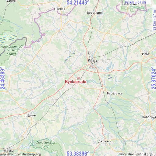
Byelagruda GPS coordinates[2]
53° 48' 4.608" North, 25° 10' 1.596" East
| Map corner | latitude | longitude |
|---|---|---|
| Upper-left | 54.21448°, | 24.46399° |
| Center: | 53.80128°, | 25.16711° |
| Lower-right: | 53.38396°, | 25.87024° |
| Map W x H: | 92.3×92.3 km | = 57.4×57.4mi |
| max Lat: | 56.0147° ⇑46.4% North |
| Byelagruda: | 53.80128° |
| min Lat: | ⇓53.6% South 51.75° |
| min Long | Byelagruda | max Long |
| 23.37083° | 25.16711° | 32.578° |
| W 10.5%⇐ | ⇒89.5% E |
Elevation
Elevation of Byelagruda is 143 m = 469 ft, and this is 25.6 m = 84 ft below average elevation for this country.
| Max E: |
309 m = 1014 ft | 77.3% |
| Avg. | 168.6 m = 553 ft | |
| Byelagruda | 143 m = 469 ft | |
Min E: |
108 m = 354 ft | 22.7% |
See also: Belarus elevation on elevation.city.
Geographical zone
Byelagruda is located in North temperate zone (between Tropic of Cancer and the Arctic Circle). Distance of this North polar circle is 1419 km =881.7 mi to North.| Distance of | km | miles | from Byelagruda |
|---|---|---|---|
| North Pole | 4024.9 | 2501 | to North |
| Arctic Circle | 1419 | 881.7 | to North |
| Tropic Cancer | 3376.2 | 2097.9 | to South |
| Equator | 5982.1 | 3717.1 | to South |


Nearby cities:
15 places around Byelagruda: (largest is in red/bold)
• Azyory
65.2 km =40.5 mi,  262°
262°
• Byarozawka
23.3 km =14.5 mi,  111°
111°
• Dyatlovo
40.8 km =25.4 mi,  157°
157°
• Hyeranyony
44.1 km =27.4 mi,  37°
37°
• Iwye
42.2 km =26.2 mi,  70°
70°
• Lida
12.6 km =7.8 mi, 43°
• Lyubcha
58.9 km =36.6 mi,  95°
95°
• Mosty
59.9 km =37.2 mi,  223°
223°
• Novogrudok
48.7 km =30.3 mi,  118°
118°
• Shchuchyn
35.5 km =22.1 mi,  231°
231°
• Skidel’
64.9 km =40.3 mi,  248°
248°
• Traby
62.6 km =38.9 mi,  50°
50°
• Voranava
39.8 km =24.7 mi,  13°
13°
• Vselyub
42.5 km =26.4 mi, 102°
• Zhaludok
25.7 km =16 mi,  208°
208°
Sources, notices
• [Note1] Compared only with cities in Belarus existing in our database
• [Src1] Map data: © OpenStreetMap contributors (CC-BY-SA)
• [Src2] Other city data from geonames.org with taken over terms of usage.
• [Src3] Geographical zone / Annual Mean Temperature by Robert A. Rohde @ Wikipedia
