Mazyr geodata
Mazyr (Gomel Oblast) is a seat of a second-order administrative division; located in Belarus in Europe/Minsk (GMT+3) time zone. With population of 112,137 people, there are 11 cities with bigger population in this country. Compared to other cities in Belarus, 96.7% of cities are located further ↑North; 71.7% of cities are located further ←West and 64.1% of cities have higher elevation than Mazyr. Note1


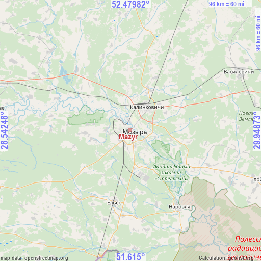
Mazyr GPS coordinates[2]
52° 2' 58.2" North, 29° 14' 44.16" East
| Map corner | latitude | longitude |
|---|---|---|
| Upper-left | 52.47982°, | 28.54248° |
| Center: | 52.0495°, | 29.2456° |
| Lower-right: | 51.615°, | 29.94873° |
| Map W x H: | 96.2×96.2 km | = 59.8×59.8mi |
| max Lat: | 56.0147° ⇑96.7% North |
| Mazyr: | 52.0495° |
| min Lat: | ⇓3.3% South 51.75° |
| min Long | Mazyr | max Long |
| 23.37083° | 29.2456° | 32.578° |
| W 71.7%⇐ | ⇒28.3% E |
Elevation
Elevation of Mazyr is 152 m = 499 ft, and this is 16.6 m = 54 ft below average elevation for this country.
| Max E: |
309 m = 1014 ft | 64.1% |
| Avg. | 168.6 m = 553 ft | |
| Mazyr | 152 m = 499 ft | |
Min E: |
108 m = 354 ft | 35.9% |
See also: Mazyr elevation on elevation.city.
Geographical zone
Mazyr is located in North temperate zone (between Tropic of Cancer and the Arctic Circle). Distance of this North polar circle is 1613.8 km =1002.8 mi to North.| Distance of | km | miles | from Mazyr |
|---|---|---|---|
| North Pole | 4219.7 | 2622 | to North |
| Arctic Circle | 1613.8 | 1002.8 | to North |
| Tropic Cancer | 3181.4 | 1976.8 | to South |
| Equator | 5787.4 | 3596.1 | to South |


Nearby cities:
15 places around Mazyr: (largest is in red/bold)
• Aktsyabrski
70.6 km =43.9 mi,  339°
339°
• Brahin
75.9 km =47.2 mi,  112°
112°
• Horad Rechytsa
85.7 km =53.3 mi,  65°
65°
• Kalinkavichy
10.7 km =6.6 mi,  30°
30°
• Khoyniki
51.7 km =32.1 mi, 109°
• Lyel’chytsy
69.4 km =43.1 mi,  245°
245°
• Narowlya
33.2 km =20.6 mi,  148°
148°
• Parychy
84.7 km =52.6 mi,  7°
7°
• Pyetrykaw
52.2 km =32.4 mi,  279°
279°
• Rechytsa
85.5 km =53.1 mi, 66°
• Sasnovy Bor
57.5 km =35.7 mi,  24°
24°
• Svyetlahorsk
73 km =45.4 mi, 27°
• Vasilyevichy
45.7 km =28.4 mi,  60°
60°
• Yel’sk
26.9 km =16.7 mi,  193°
193°
• Zhytkavichy
96.6 km =60 mi, 281°
Sources, notices
• [Note1] Compared only with cities in Belarus existing in our database
• [Src1] Map data: © OpenStreetMap contributors (CC-BY-SA)
• [Src2] Other city data from geonames.org with taken over terms of usage.
• [Src3] Geographical zone / Annual Mean Temperature by Robert A. Rohde @ Wikipedia
