Rechytsa geodata
Rechytsa (Gomel Oblast) is a seat of a second-order administrative division; located in Belarus in Europe/Minsk (GMT+3) time zone. With population of 65,400 people, there are 19 cities with bigger population in this country. Compared to other cities in Belarus, 88.2% of cities are located further ↑North; 87.5% of cities are located further ←West and 95.1% of cities have higher elevation than Rechytsa. Note1


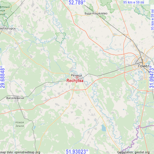
Rechytsa GPS coordinates[2]
52° 21' 42.12" North, 30° 23' 29.76" East
| Map corner | latitude | longitude |
|---|---|---|
| Upper-left | 52.789°, | 29.68848° |
| Center: | 52.3617°, | 30.3916° |
| Lower-right: | 51.93023°, | 31.09473° |
| Map W x H: | 95.5×95.5 km | = 59.3×59.3mi |
| max Lat: | 56.0147° ⇑88.2% North |
| Rechytsa: | 52.3617° |
| min Lat: | ⇓11.8% South 51.75° |
| min Long | Rechytsa | max Long |
| 23.37083° | 30.3916° | 32.578° |
| W 87.5%⇐ | ⇒12.5% E |
Elevation
Elevation of Rechytsa is 128 m = 420 ft, and this is 40.6 m = 133 ft below average elevation for this country.
| Max E: |
309 m = 1014 ft | 95.1% |
| Avg. | 168.6 m = 553 ft | |
| Rechytsa | 128 m = 420 ft | |
Min E: |
108 m = 354 ft | 4.9% |
See also: Rechytsa elevation on elevation.city.
Geographical zone
Rechytsa is located in North temperate zone (between Tropic of Cancer and the Arctic Circle). Distance of this North polar circle is 1579.1 km =981.2 mi to North.| Distance of | km | miles | from Rechytsa |
|---|---|---|---|
| North Pole | 4185 | 2600.4 | to North |
| Arctic Circle | 1579.1 | 981.2 | to North |
| Tropic Cancer | 3216.2 | 1998.5 | to South |
| Equator | 5822.1 | 3617.7 | to South |


Nearby cities:
15 places around Rechytsa: (largest is in red/bold)
• Buda-Kashalyova
41.4 km =25.7 mi,  16°
16°
• Dobrush
63.5 km =39.5 mi,  85°
85°
• Homyel'
40.4 km =25.1 mi,  78°
78°
• Horad Rechytsa
0.3 km =0.2 mi,  41°
41°
• Karanyowka
48.9 km =30.4 mi, 91°
• Kastsyukowka
40.7 km =25.3 mi,  61°
61°
• Khal’ch
55.3 km =34.4 mi,  65°
65°
• Khoyniki
60.2 km =37.4 mi,  209°
209°
• Loyew
53.8 km =33.4 mi,  149°
149°
• Novaya Huta
49.5 km =30.8 mi,  125°
125°
• Peramoga
46.3 km =28.8 mi, 85°
• Sasnovy Bor
56.5 km =35.1 mi,  288°
288°
• Svyetlahorsk
53.5 km =33.2 mi,  304°
304°
• Vasilyevichy
40.2 km =25 mi,  252°
252°
• Vyetka
57.7 km =35.9 mi, 67°
Sources, notices
• [Note1] Compared only with cities in Belarus existing in our database
• [Src1] Map data: © OpenStreetMap contributors (CC-BY-SA)
• [Src2] Other city data from geonames.org with taken over terms of usage.
• [Src3] Geographical zone / Annual Mean Temperature by Robert A. Rohde @ Wikipedia
