Malaryta geodata
Malaryta (Brest) is a seat of a second-order administrative division; located in Belarus in Europe/Minsk (GMT+3) time zone. With population of 9,692 people, there are 90 cities with bigger population in this country. Compared to other cities in Belarus, 99% of cities are located further ↑North; 95.7% of cities are located further →East and 60.5% of cities have higher elevation than Malaryta. Note1


Malaryta GPS coordinates[2]
51° 47' 25.8" North, 24° 4' 26.4" East
| Map corner | latitude | longitude |
|---|---|---|
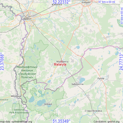
| Upper-left | 52.22332°, | 23.37088° |
| Center: | 51.7905°, | 24.074° |
| Lower-right: | 51.35349°, | 24.77713° |
| Map W x H: | 96.7×96.7 km | = 60.1×60.1mi |
| max Lat: | 56.0147° ⇑99% North |
| Malaryta: | 51.7905° |
| min Lat: | ⇓1% South 51.75° |
| min Long | Malaryta | max Long |
| 23.37083° | 24.074° | 32.578° |
| W 4.3%⇐ | ⇒95.7% E |
Elevation
Elevation of Malaryta is 157 m = 515 ft, and this is 11.6 m = 38 ft below average elevation for this country.
| Max E: |
309 m = 1014 ft | 60.5% |
| Avg. | 168.6 m = 553 ft | |
| Malaryta | 157 m = 515 ft | |
Min E: |
108 m = 354 ft | 39.5% |
See also: Belarus elevation on elevation.city.
Geographical zone
Malaryta is located in North temperate zone (between Tropic of Cancer and the Arctic Circle). Distance of this North polar circle is 1642.6 km =1020.7 mi to North.| Distance of | km | miles | from Malaryta |
|---|---|---|---|
| North Pole | 4248.5 | 2639.9 | to North |
| Arctic Circle | 1642.6 | 1020.7 | to North |
| Tropic Cancer | 3152.6 | 1958.9 | to South |
| Equator | 5758.6 | 3578.2 | to South |


Nearby cities:
15 places around Malaryta: (largest is in red/bold)
• Antopal’
67 km =41.6 mi,  46°
46°
• Brest
43.2 km =26.8 mi,  322°
322°
• Byaroza
102.9 km =63.9 mi,  36°
36°
• Charnawchytsy
52.9 km =32.9 mi,  334°
334°
• Damachava
32.9 km =20.4 mi,  262°
262°
• Drahichyn
86.5 km =53.7 mi,  59°
59°
• Horad Kobryn
51.4 km =31.9 mi,  22°
22°
• Kamyanyets
70.1 km =43.6 mi,  345°
345°
• Kamyanyuki
87.2 km =54.2 mi, 347°
• Kobryn
50.9 km =31.6 mi, 22°
• Pruzhany
89 km =55.3 mi, 17°
• Skoki
50.6 km =31.4 mi, 323°
• Vysokaye
80.5 km =50 mi, 323°
• Zhabinka
45.6 km =28.3 mi, 354°
• Znamenka
30.5 km =19 mi,  289°
289°
Sources, notices
• [Note1] Compared only with cities in Belarus existing in our database
• [Src1] Map data: © OpenStreetMap contributors (CC-BY-SA)
• [Src2] Other city data from geonames.org with taken over terms of usage.
• [Src3] Geographical zone / Annual Mean Temperature by Robert A. Rohde @ Wikipedia
