Kastsyukovichy geodata
Kastsyukovichy (Mogilev) is a seat of a second-order administrative division; located in Belarus in Europe/Minsk (GMT+3) time zone. With population of 11,946 people, there are 66 cities with bigger population in this country. Compared to other cities in Belarus, 65.8% of cities are located further ↑North; 99.7% of cities are located further ←West and 57.2% of cities have lower elevation than Kastsyukovichy. Note1


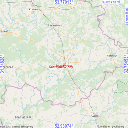
Kastsyukovichy GPS coordinates[2]
53° 21' 9" North, 32° 3' 5.04" East
| Map corner | latitude | longitude |
|---|---|---|
| Upper-left | 53.77013°, | 31.34828° |
| Center: | 53.3525°, | 32.0514° |
| Lower-right: | 52.93074°, | 32.75453° |
| Map W x H: | 93.3×93.3 km | = 58×58mi |
| max Lat: | 56.0147° ⇑65.8% North |
| Kastsyukovichy: | 53.3525° |
| min Lat: | ⇓34.2% South 51.75° |
| min Long | Kastsyukovichy | max Long |
| 23.37083° | 32.0514° | 32.578° |
| W 99.7%⇐ | ⇒0.3% E |
Elevation
Elevation of Kastsyukovichy is 172 m = 564 ft, and this is 3.4 m = 11 ft above average elevation for this country.
| Max E: |
309 m = 1014 ft | 42.8% |
| Kastsyukovichy | 172 m 564 ft | |
| Avg. | 168.6 m = 553 ft | |
Min E: |
108 m = 354 ft | 57.2% |
See also: Belarus elevation on elevation.city.
Geographical zone
Kastsyukovichy is located in North temperate zone (between Tropic of Cancer and the Arctic Circle). Distance of this North polar circle is 1468.9 km =912.7 mi to North.| Distance of | km | miles | from Kastsyukovichy |
|---|---|---|---|
| North Pole | 4074.8 | 2532 | to North |
| Arctic Circle | 1468.9 | 912.7 | to North |
| Tropic Cancer | 3326.3 | 2066.9 | to South |
| Equator | 5932.2 | 3686.1 | to South |


Nearby cities:
15 places around Kastsyukovichy: (largest is in red/bold)
• Chachersk
89.8 km =55.8 mi,  237°
237°
• Chavusy
87.5 km =54.4 mi,  305°
305°
• Cherykaw
50.4 km =31.3 mi,  298°
298°
• Harbavichy
103.1 km =64.1 mi, 300°
• Horad Krychaw
44.5 km =27.7 mi,  329°
329°
• Karma
86.8 km =53.9 mi,  253°
253°
• Khodasy
74.2 km =46.1 mi, 329°
• Khotsimsk
35.5 km =22.1 mi,  79°
79°
• Klimavichy
29.1 km =18.1 mi,  347°
347°
• Krasnapollye
43.3 km =26.9 mi,  267°
267°
• Krychaw
45.7 km =28.4 mi, 331°
• Mstsislaw
77.2 km =48 mi,  343°
343°
• Ryasno, Рясно, Расна
102.8 km =63.9 mi,  292°
292°
• Slawharad
70.3 km =43.7 mi,  278°
278°
• Vyetka
105.8 km =65.7 mi,  213°
213°
Sources, notices
• [Note1] Compared only with cities in Belarus existing in our database
• [Src1] Map data: © OpenStreetMap contributors (CC-BY-SA)
• [Src2] Other city data from geonames.org with taken over terms of usage.
• [Src3] Geographical zone / Annual Mean Temperature by Robert A. Rohde @ Wikipedia
