Chachersk geodata
Chachersk (Gomel Oblast) is a populated place; located in Belarus in Europe/Minsk (GMT+3) time zone. With population of 7,600 people, there are 112 cities with bigger population in this country. Compared to other cities in Belarus, 77.3% of cities are located further ↑North; 93.4% of cities are located further ←West and 75.3% of cities have higher elevation than Chachersk. Note1


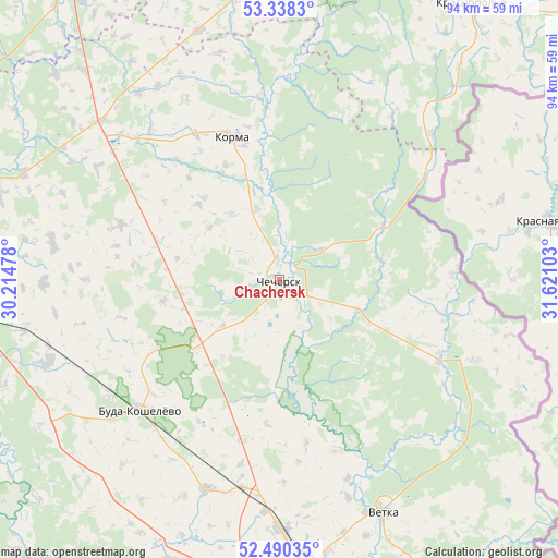
Chachersk GPS coordinates[2]
52° 54' 59.04" North, 30° 55' 4.44" East
| Map corner | latitude | longitude |
|---|---|---|
| Upper-left | 53.3383°, | 30.21478° |
| Center: | 52.9164°, | 30.9179° |
| Lower-right: | 52.49035°, | 31.62103° |
| Map W x H: | 94.3×94.3 km | = 58.6×58.6mi |
| max Lat: | 56.0147° ⇑77.3% North |
| Chachersk: | 52.9164° |
| min Lat: | ⇓22.7% South 51.75° |
| min Long | Chachersk | max Long |
| 23.37083° | 30.9179° | 32.578° |
| W 93.4%⇐ | ⇒6.6% E |
Elevation
Elevation of Chachersk is 146 m = 479 ft, and this is 22.6 m = 74 ft below average elevation for this country.
| Max E: |
309 m = 1014 ft | 75.3% |
| Avg. | 168.6 m = 553 ft | |
| Chachersk | 146 m = 479 ft | |
Min E: |
108 m = 354 ft | 24.7% |
See also: Belarus elevation on elevation.city.
Geographical zone
Chachersk is located in North temperate zone (between Tropic of Cancer and the Arctic Circle). Distance of this North polar circle is 1517.4 km =942.9 mi to North.| Distance of | km | miles | from Chachersk |
|---|---|---|---|
| North Pole | 4123.3 | 2562.1 | to North |
| Arctic Circle | 1517.4 | 942.9 | to North |
| Tropic Cancer | 3277.8 | 2036.7 | to South |
| Equator | 5883.8 | 3656 | to South |


Nearby cities:
15 places around Chachersk: (largest is in red/bold)
• Buda-Kashalyova
32.1 km =19.9 mi,  226°
226°
• Dobrush
62.7 km =39 mi,  154°
154°
• Dowsk
40.7 km =25.3 mi,  311°
311°
• Homyel'
53.7 km =33.4 mi,  175°
175°
• Karanyowka
64.3 km =40 mi,  168°
168°
• Karma
25 km =15.5 mi,  341°
341°
• Kastsyukowka
42 km =26.1 mi, 180°
• Khal’ch
41.8 km =26 mi,  159°
159°
• Krasnapollye
56.6 km =35.2 mi,  34°
34°
• Krasnyy Bereg
66.7 km =41.4 mi, 313°
• Peramoga
58.6 km =36.4 mi, 169°
• Rahachow
61.3 km =38.1 mi,  288°
288°
• Slawharad
58.8 km =36.5 mi,  5°
5°
• Vyetka
43.5 km =27 mi, 156°
• Zhlobin
60 km =37.3 mi,  267°
267°
Sources, notices
• [Note1] Compared only with cities in Belarus existing in our database
• [Src1] Map data: © OpenStreetMap contributors (CC-BY-SA)
• [Src2] Other city data from geonames.org with taken over terms of usage.
• [Src3] Geographical zone / Annual Mean Temperature by Robert A. Rohde @ Wikipedia
