Biggar geodata
Biggar (Saskatchewan) is a populated place; located in Canada in America/Regina (GMT-6) time zone. With population of 2,068 people, there are 739 cities with bigger population in this country. Compared to other cities in Canada, 86% of cities are located further ↓South; 73.7% of cities are located further →East and 89.6% of cities have lower elevation than Biggar. Note1


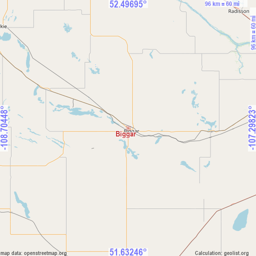
Biggar GPS coordinates[2]
52° 4' 0.48" North, 108° 0' 4.86" West
| Map corner | latitude | longitude |
|---|---|---|
| Upper-left | 52.49695°, | -108.70448° |
| Center: | 52.0668°, | -108.00135° |
| Lower-right: | 51.63246°, | -107.29823° |
| Map W x H: | 96.1×96.1 km | = 59.7×59.7mi |
| max Lat: | 73.03752° ⇑14% North |
| Biggar: | 52.0668° |
| min Lat: | ⇓86% South 42.05009° |
| min Long | Biggar | max Long |
| -139.43328° | -108.00135° | -52.70931° |
| W 26.3%⇐ | ⇒73.7% E |
Elevation
Elevation of Biggar is 661 m = 2169 ft, and this is 406.6 m = 1334 ft above average elevation for this country.
| Max E: |
1518 m = 4980 ft | 10.4% |
| Biggar | 661 m 2169 ft | |
| Avg. | 254.4 m = 835 ft | |
Min E: |
-2 m = -7 ft | 89.6% |
See also: Canada elevation on elevation.city.
Geographical zone
Biggar is located in North temperate zone (between Tropic of Cancer and the Arctic Circle). Distance of this North polar circle is 1611.9 km =1001.6 mi to North.| Distance of | km | miles | from Biggar |
|---|---|---|---|
| North Pole | 4217.8 | 2620.8 | to North |
| Arctic Circle | 1611.9 | 1001.6 | to North |
| Tropic Cancer | 3183.4 | 1978.1 | to South |
| Equator | 5789.3 | 3597.3 | to South |


Nearby cities:
15 places around Biggar: (largest is in red/bold)
• Dalmeny
89.1 km =55.4 mi,  70°
70°
• Eston
114.3 km =71 mi,  206°
206°
• Kerrobert
79.4 km =49.3 mi,  257°
257°
• Kindersley
104.4 km =64.9 mi,  230°
230°
• Langham
77.9 km =48.4 mi,  64°
64°
• Macklin
135.1 km =83.9 mi,  282°
282°
• Martensville
94.1 km =58.5 mi,  75°
75°
• North Battleford
81.8 km =50.8 mi,  345°
345°
• Outlook
90.8 km =56.4 mi,  133°
133°
• Rosetown
57.5 km =35.7 mi,  180°
180°
• Rosthern
131.4 km =81.6 mi, 59°
• Saskatoon
91.3 km =56.7 mi,  85°
85°
• Unity
90.1 km =56 mi,  298°
298°
• Warman
101.6 km =63.1 mi, 74°
• Wilkie
61.5 km =38.2 mi,  309°
309°
Sources, notices
• [Note1] Compared only with cities in Canada existing in our database
• [Src1] Map data: © OpenStreetMap contributors (CC-BY-SA)
• [Src2] Other city data from geonames.org with taken over terms of usage.
• [Src3] Geographical zone / Annual Mean Temperature by Robert A. Rohde @ Wikipedia
