Saskatoon geodata
Saskatoon (Saskatchewan) is a populated place; located in Canada in America/Regina (GMT-6) time zone. With population of 198,958 people, there are 29 cities with bigger population in this country. Compared to other cities in Canada, 86.2% of cities are located further ↓South; 73.3% of cities are located further →East and 81% of cities have lower elevation than Saskatoon. Note1


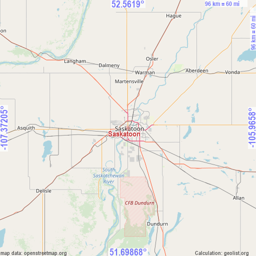
Saskatoon GPS coordinates[2]
52° 7' 56.568" North, 106° 40' 8.112" West
| Map corner | latitude | longitude |
|---|---|---|
| Upper-left | 52.5619°, | -107.37205° |
| Center: | 52.13238°, | -106.66892° |
| Lower-right: | 51.69868°, | -105.9658° |
| Map W x H: | 96×96 km | = 59.7×59.7mi |
| max Lat: | 73.03752° ⇑13.8% North |
| Saskatoon: | 52.13238° |
| min Lat: | ⇓86.2% South 42.05009° |
| min Long | Saskatoon | max Long |
| -139.43328° | -106.66892° | -52.70931° |
| W 26.7%⇐ | ⇒73.3% E |
Elevation
Elevation of Saskatoon is 484 m = 1588 ft, and this is 229.6 m = 753 ft above average elevation for this country.
| Max E: |
1518 m = 4980 ft | 19% |
| Saskatoon | 484 m 1588 ft | |
| Avg. | 254.4 m = 835 ft | |
Min E: |
-2 m = -7 ft | 81% |
See also: Saskatoon elevation on elevation.city.
Geographical zone
Saskatoon is located in North temperate zone (between Tropic of Cancer and the Arctic Circle). Distance of this North polar circle is 1604.6 km =997.1 mi to North.| Distance of | km | miles | from Saskatoon |
|---|---|---|---|
| North Pole | 4210.5 | 2616.3 | to North |
| Arctic Circle | 1604.6 | 997.1 | to North |
| Tropic Cancer | 3190.7 | 1982.6 | to South |
| Equator | 5796.6 | 3601.8 | to South |


Nearby cities:
15 places around Saskatoon: (largest is in red/bold)
• Biggar
91.3 km =56.7 mi,  265°
265°
• Dalmeny
23.3 km =14.5 mi,  343°
343°
• Davidson
107.2 km =66.6 mi,  153°
153°
• Humboldt
105.5 km =65.6 mi,  85°
85°
• Langham
33.1 km =20.6 mi,  322°
322°
• Lanigan
116.2 km =72.2 mi,  105°
105°
• Martensville
16.8 km =10.4 mi,  0°
0°
• North Battleford
131.7 km =81.8 mi,  303°
303°
• Outlook
75.1 km =46.7 mi,  200°
200°
• Prince Albert
133.4 km =82.9 mi,  27°
27°
• Rosetown
112.1 km =69.7 mi,  234°
234°
• Rosthern
63.6 km =39.5 mi,  20°
20°
• Shellbrook
121.9 km =75.7 mi,  8°
8°
• Warman
21.6 km =13.4 mi, 18°
• Watrous
97.3 km =60.5 mi,  122°
122°
Sources, notices
• [Note1] Compared only with cities in Canada existing in our database
• [Src1] Map data: © OpenStreetMap contributors (CC-BY-SA)
• [Src2] Other city data from geonames.org with taken over terms of usage.
• [Src3] Geographical zone / Annual Mean Temperature by Robert A. Rohde @ Wikipedia
