Canmore geodata
Canmore (Alberta) is a populated place; located in Canada in America/Edmonton (GMT-6) time zone. With population of 12,288 people, there are 273 cities with bigger population in this country. Compared to other cities in Canada, 82.7% of cities are located further ↓South; 83.5% of cities are located further →East and 99.8% of cities have lower elevation than Canmore. Note1


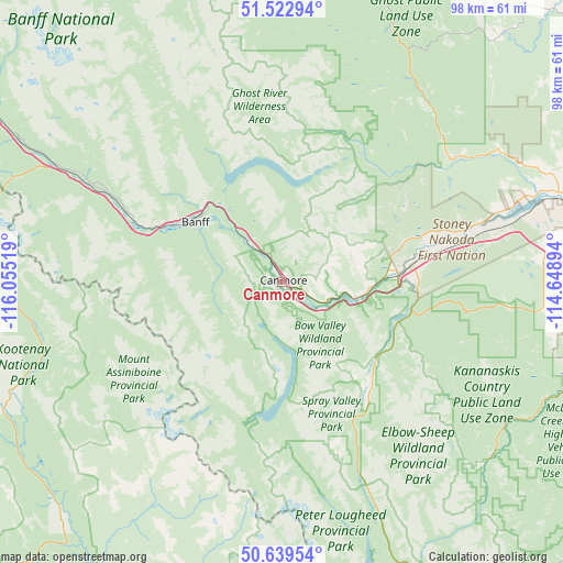
Canmore GPS coordinates[2]
51° 5' 0.06" North, 115° 21' 7.416" West
| Map corner | latitude | longitude |
|---|---|---|
| Upper-left | 51.52294°, | -116.05519° |
| Center: | 51.08335°, | -115.35206° |
| Lower-right: | 50.63954°, | -114.64894° |
| Map W x H: | 98.2×98.2 km | = 61×61mi |
| max Lat: | 73.03752° ⇑17.3% North |
| Canmore: | 51.08335° |
| min Lat: | ⇓82.7% South 42.05009° |
| min Long | Canmore | max Long |
| -139.43328° | -115.35206° | -52.70931° |
| W 16.5%⇐ | ⇒83.5% E |
Elevation
Elevation of Canmore is 1309 m = 4295 ft, and this is 1054.6 m = 3460 ft above average elevation for this country.
| Max E: |
1518 m = 4980 ft | 0.2% |
| Canmore | 1309 m 4295 ft | |
| Avg. | 254.4 m = 835 ft | |
Min E: |
-2 m = -7 ft | 99.8% |
See also: Canada elevation on elevation.city.
Geographical zone
Canmore is located in North temperate zone (between Tropic of Cancer and the Arctic Circle). Distance of this North polar circle is 1721.2 km =1069.5 mi to North.| Distance of | km | miles | from Canmore |
|---|---|---|---|
| North Pole | 4327.1 | 2688.7 | to North |
| Arctic Circle | 1721.2 | 1069.5 | to North |
| Tropic Cancer | 3074 | 1910.1 | to South |
| Equator | 5679.9 | 3529.3 | to South |


Nearby cities:
15 places around Canmore: (largest is in red/bold)
• Airdrie
94.9 km =59 mi,  75°
75°
• Banff
18.4 km =11.4 mi,  304°
304°
• Black Diamond
89.2 km =55.4 mi,  118°
118°
• Bragg Creek
57.3 km =35.6 mi,  104°
104°
• Calgary
88.6 km =55.1 mi,  92°
92°
• Carstairs
102.1 km =63.4 mi,  58°
58°
• Chestermere
107.3 km =66.7 mi, 92°
• Cochrane
62.6 km =38.9 mi, 79°
• Crossfield
99.5 km =61.8 mi,  66°
66°
• Didsbury
106.5 km =66.2 mi,  52°
52°
• Golden
115.2 km =71.6 mi,  282°
282°
• Heritage Pointe
98.1 km =61 mi,  105°
105°
• Invermere
79.2 km =49.2 mi,  217°
217°
• Okotoks
103.8 km =64.5 mi, 112°
• Sundre
93.9 km =58.3 mi,  31°
31°
Sources, notices
• [Note1] Compared only with cities in Canada existing in our database
• [Src1] Map data: © OpenStreetMap contributors (CC-BY-SA)
• [Src2] Other city data from geonames.org with taken over terms of usage.
• [Src3] Geographical zone / Annual Mean Temperature by Robert A. Rohde @ Wikipedia
