Okotoks geodata
Okotoks (Alberta) is a populated place; located in Canada in America/Edmonton (GMT-6) time zone. With population of 14,826 people, there are 244 cities with bigger population in this country. Compared to other cities in Canada, 81% of cities are located further ↓South; 81.3% of cities are located further →East and 98.7% of cities have lower elevation than Okotoks. Note1


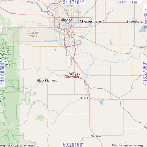
Okotoks GPS coordinates[2]
50° 43' 43.86" North, 113° 58' 58.116" West
| Map corner | latitude | longitude |
|---|---|---|
| Upper-left | 51.17181°, | -114.68594° |
| Center: | 50.72885°, | -113.98281° |
| Lower-right: | 50.28166°, | -113.27969° |
| Map W x H: | 99×99 km | = 61.5×61.5mi |
| max Lat: | 73.03752° ⇑19% North |
| Okotoks: | 50.72885° |
| min Lat: | ⇓81% South 42.05009° |
| min Long | Okotoks | max Long |
| -139.43328° | -113.98281° | -52.70931° |
| W 18.7%⇐ | ⇒81.3% E |
Elevation
Elevation of Okotoks is 1071 m = 3514 ft, and this is 816.6 m = 2679 ft above average elevation for this country.
| Max E: |
1518 m = 4980 ft | 1.3% |
| Okotoks | 1071 m 3514 ft | |
| Avg. | 254.4 m = 835 ft | |
Min E: |
-2 m = -7 ft | 98.7% |
See also: Canada elevation on elevation.city.
Geographical zone
Okotoks is located in North temperate zone (between Tropic of Cancer and the Arctic Circle). Distance of this North polar circle is 1760.7 km =1094 mi to North.| Distance of | km | miles | from Okotoks |
|---|---|---|---|
| North Pole | 4366.5 | 2713.2 | to North |
| Arctic Circle | 1760.7 | 1094 | to North |
| Tropic Cancer | 3034.6 | 1885.6 | to South |
| Equator | 5640.5 | 3504.8 | to South |


Nearby cities:
15 places around Okotoks: (largest is in red/bold)
• Airdrie
63.6 km =39.5 mi,  356°
356°
• Black Diamond
18.1 km =11.2 mi,  259°
259°
• Bragg Creek
47.5 km =29.5 mi,  301°
301°
• Calgary
36.4 km =22.6 mi,  348°
348°
• Carstairs
93.5 km =58.1 mi, 354°
• Chestermere
35.8 km =22.2 mi,  18°
18°
• Claresholm
82.3 km =51.1 mi,  159°
159°
• Cochrane
60.9 km =37.8 mi,  326°
326°
• Crossfield
78.4 km =48.7 mi, 357°
• Heritage Pointe
12.7 km =7.9 mi, 352°
• High River
18.1 km =11.2 mi,  153°
153°
• Irricana
71.2 km =44.2 mi, 21°
• Nanton
44.8 km =27.8 mi, 160°
• Strathmore
55.1 km =34.2 mi,  49°
49°
• Vulcan
63.3 km =39.3 mi,  125°
125°
Sources, notices
• [Note1] Compared only with cities in Canada existing in our database
• [Src1] Map data: © OpenStreetMap contributors (CC-BY-SA)
• [Src2] Other city data from geonames.org with taken over terms of usage.
• [Src3] Geographical zone / Annual Mean Temperature by Robert A. Rohde @ Wikipedia
