Heritage Pointe geodata
Heritage Pointe (Alberta) is a populated place; located in Canada in America/Edmonton (GMT-6) time zone. With population of 2,075 people, there are 737 cities with bigger population in this country. Compared to other cities in Canada, 81.6% of cities are located further ↓South; 81.5% of cities are located further →East and 97.5% of cities have lower elevation than Heritage Pointe. Note1


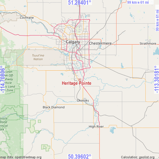
Heritage Pointe GPS coordinates[2]
50° 50' 31.668" North, 114° 0' 17.748" West
| Map corner | latitude | longitude |
|---|---|---|
| Upper-left | 51.28401°, | -114.70806° |
| Center: | 50.84213°, | -114.00493° |
| Lower-right: | 50.39602°, | -113.30181° |
| Map W x H: | 98.7×98.7 km | = 61.3×61.3mi |
| max Lat: | 73.03752° ⇑18.4% North |
| Heritage Pointe: | 50.84213° |
| min Lat: | ⇓81.6% South 42.05009° |
| min Long | Heritage Pointe | max Long |
| -139.43328° | -114.00493° | -52.70931° |
| W 18.5%⇐ | ⇒81.5% E |
Elevation
Elevation of Heritage Pointe is 1014 m = 3327 ft, and this is 759.6 m = 2492 ft above average elevation for this country.
| Max E: |
1518 m = 4980 ft | 2.5% |
| Heritage Pointe | 1014 m 3327 ft | |
| Avg. | 254.4 m = 835 ft | |
Min E: |
-2 m = -7 ft | 97.5% |
See also: Canada elevation on elevation.city.
Geographical zone
Heritage Pointe is located in North temperate zone (between Tropic of Cancer and the Arctic Circle). Distance of this North polar circle is 1748.1 km =1086.2 mi to North.| Distance of | km | miles | from Heritage Pointe |
|---|---|---|---|
| North Pole | 4353.9 | 2705.4 | to North |
| Arctic Circle | 1748.1 | 1086.2 | to North |
| Tropic Cancer | 3047.2 | 1893.4 | to South |
| Equator | 5653.1 | 3512.7 | to South |


Nearby cities:
15 places around Heritage Pointe: (largest is in red/bold)
• Airdrie
51 km =31.7 mi,  357°
357°
• Black Diamond
22.6 km =14 mi,  225°
225°
• Bragg Creek
40.8 km =25.4 mi,  287°
287°
• Calgary
23.8 km =14.8 mi,  346°
346°
• Carstairs
80.9 km =50.3 mi, 355°
• Chestermere
25 km =15.5 mi,  31°
31°
• Cochrane
49.9 km =31 mi,  319°
319°
• Crossfield
65.8 km =40.9 mi, 358°
• Didsbury
92.1 km =57.2 mi, 354°
• High River
30.3 km =18.8 mi,  161°
161°
• Irricana
60.4 km =37.5 mi, 27°
• Nanton
57.2 km =35.5 mi, 163°
• Okotoks
12.7 km =7.9 mi,  172°
172°
• Strathmore
49.2 km =30.6 mi,  61°
61°
• Vulcan
72.4 km =45 mi,  132°
132°
Sources, notices
• [Note1] Compared only with cities in Canada existing in our database
• [Src1] Map data: © OpenStreetMap contributors (CC-BY-SA)
• [Src2] Other city data from geonames.org with taken over terms of usage.
• [Src3] Geographical zone / Annual Mean Temperature by Robert A. Rohde @ Wikipedia
