Coaticook geodata
Coaticook (Quebec) is a populated place; located in Canada in America/Toronto (GMT-4) time zone. With population of 7,021 people, there are 401 cities with bigger population in this country. Compared to other cities in Canada, 82.9% of cities are located further ↑North; 77.6% of cities are located further ←West and 68.8% of cities have lower elevation than Coaticook. Note1


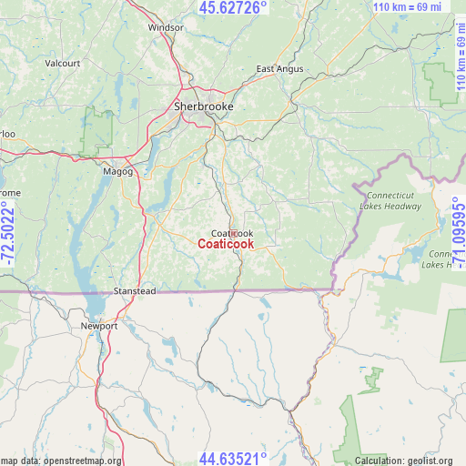
Coaticook GPS coordinates[2]
45° 8' 0.204" North, 71° 47' 56.652" West
| Map corner | latitude | longitude |
|---|---|---|
| Upper-left | 45.62726°, | -72.5022° |
| Center: | 45.13339°, | -71.79907° |
| Lower-right: | 44.63521°, | -71.09595° |
| Map W x H: | 110.3×110.3 km | = 68.5×68.5mi |
| max Lat: | 73.03752° ⇑82.9% North |
| Coaticook: | 45.13339° |
| min Lat: | ⇓17.1% South 42.05009° |
| min Long | Coaticook | max Long |
| -139.43328° | -71.79907° | -52.70931° |
| W 77.6%⇐ | ⇒22.4% E |
Elevation
Elevation of Coaticook is 289 m = 948 ft, and this is 34.6 m = 114 ft above average elevation for this country.
| Max E: |
1518 m = 4980 ft | 31.2% |
| Coaticook | 289 m 948 ft | |
| Avg. | 254.4 m = 835 ft | |
Min E: |
-2 m = -7 ft | 68.8% |
See also: Canada elevation on elevation.city.
Geographical zone
Coaticook is located in North temperate zone (between Tropic of Cancer and the Arctic Circle). Distance of this North polar circle is 2382.8 km =1480.6 mi to North.| Distance of | km | miles | from Coaticook |
|---|---|---|---|
| North Pole | 4988.7 | 3099.8 | to North |
| Arctic Circle | 2382.8 | 1480.6 | to North |
| Tropic Cancer | 2412.4 | 1499 | to South |
| Equator | 5018.4 | 3118.3 | to South |


Nearby cities:
15 places around Coaticook: (largest is in red/bold)
• Bromont
69.6 km =43.2 mi,  287°
287°
• Cookshire
34 km =21.1 mi,  22°
22°
• Cookshire-Eaton
34.1 km =21.2 mi, 22°
• East Angus
40.3 km =25 mi,  14°
14°
• Lac-Brome
56.9 km =35.4 mi,  279°
279°
• Magog
31.2 km =19.4 mi,  298°
298°
• Richmond
65.3 km =40.6 mi,  335°
335°
• Rock Forest
29.3 km =18.2 mi,  328°
328°
• Rock Island
27.2 km =16.9 mi,  238°
238°
• Sherbrooke
30.7 km =19.1 mi,  345°
345°
• Sutton
64.2 km =39.9 mi,  266°
266°
• Valcourt
57.4 km =35.7 mi,  315°
315°
• Waterloo
61.1 km =38 mi, 293°
• Weedon Centre
69.2 km =43 mi, 22°
• Windsor
50.7 km =31.5 mi, 342°
Sources, notices
• [Note1] Compared only with cities in Canada existing in our database
• [Src1] Map data: © OpenStreetMap contributors (CC-BY-SA)
• [Src2] Other city data from geonames.org with taken over terms of usage.
• [Src3] Geographical zone / Annual Mean Temperature by Robert A. Rohde @ Wikipedia
