Kentville geodata
Kentville (Nova Scotia) is a populated place; located in Canada in America/Halifax (GMT-3) time zone. With population of 12,636 people, there are 268 cities with bigger population in this country. Compared to other cities in Canada, 83.8% of cities are located further ↑North; 92.7% of cities are located further ←West and 90% of cities have higher elevation than Kentville. Note1


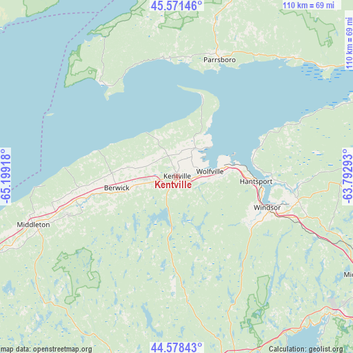
Kentville GPS coordinates[2]
45° 4' 37.56" North, 64° 29' 45.78" West
| Map corner | latitude | longitude |
|---|---|---|
| Upper-left | 45.57146°, | -65.19918° |
| Center: | 45.0771°, | -64.49605° |
| Lower-right: | 44.57843°, | -63.79293° |
| Map W x H: | 110.4×110.4 km | = 68.6×68.6mi |
| max Lat: | 73.03752° ⇑83.8% North |
| Kentville: | 45.0771° |
| min Lat: | ⇓16.2% South 42.05009° |
| min Long | Kentville | max Long |
| -139.43328° | -64.49605° | -52.70931° |
| W 92.7%⇐ | ⇒7.3% E |
Elevation
Elevation of Kentville is 15 m = 49 ft, and this is 239.4 m = 785 ft below average elevation for this country.
| Max E: |
1518 m = 4980 ft | 90% |
| Avg. | 254.4 m = 835 ft | |
| Kentville | 15 m = 49 ft | |
Min E: |
-2 m = -7 ft | 10% |
See also: Canada elevation on elevation.city.
Geographical zone
Kentville is located in North temperate zone (between Tropic of Cancer and the Arctic Circle). Distance of this North polar circle is 2389.1 km =1484.5 mi to North.| Distance of | km | miles | from Kentville |
|---|---|---|---|
| North Pole | 4995 | 3103.7 | to North |
| Arctic Circle | 2389.1 | 1484.5 | to North |
| Tropic Cancer | 2406.2 | 1495.1 | to South |
| Equator | 5012.1 | 3114.4 | to South |


Nearby cities:
15 places around Kentville: (largest is in red/bold)
• Berwick
18.8 km =11.7 mi,  260°
260°
• Boutiliers Point
62.8 km =39 mi,  136°
136°
• Chester
62.8 km =39 mi,  161°
161°
• English Corner
68 km =42.3 mi,  124°
124°
• Fall River
75.1 km =46.7 mi,  112°
112°
• Greenwood
36.1 km =22.4 mi,  251°
251°
• Hantsport
26 km =16.2 mi,  92°
92°
• Hayes Subdivision
7.6 km =4.7 mi, 251°
• Lower Sackville
72.5 km =45 mi, 117°
• Middleton
47.5 km =29.5 mi, 251°
• Parrsboro
38.9 km =24.2 mi,  20°
20°
• Port Williams
6.8 km =4.2 mi,  67°
67°
• Springhill
72.7 km =45.2 mi,  28°
28°
• Windsor
30.4 km =18.9 mi, 110°
• Wolfville
10.3 km =6.4 mi, 86°
Sources, notices
• [Note1] Compared only with cities in Canada existing in our database
• [Src1] Map data: © OpenStreetMap contributors (CC-BY-SA)
• [Src2] Other city data from geonames.org with taken over terms of usage.
• [Src3] Geographical zone / Annual Mean Temperature by Robert A. Rohde @ Wikipedia
