Parrsboro geodata
Parrsboro (Nova Scotia) is a populated place; located in Canada in America/Halifax (GMT-3) time zone. With population of 1,472 people, there are 871 cities with bigger population in this country. Compared to other cities in Canada, 78% of cities are located further ↑North; 93.2% of cities are located further ←West and 88.3% of cities have higher elevation than Parrsboro. Note1


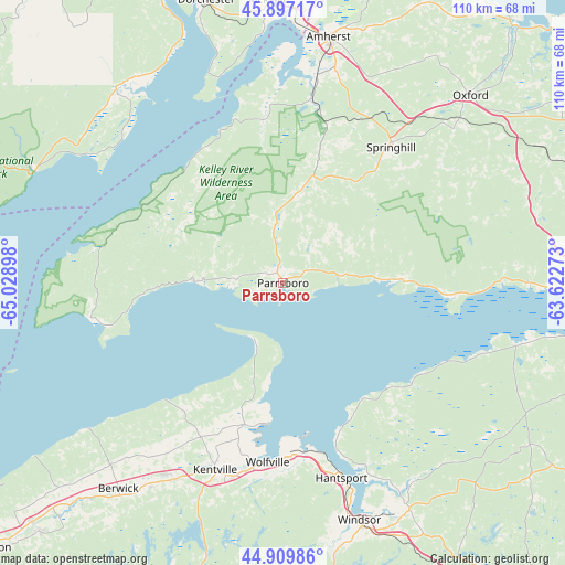
Parrsboro GPS coordinates[2]
45° 24' 20.412" North, 64° 19' 33.06" West
| Map corner | latitude | longitude |
|---|---|---|
| Upper-left | 45.89717°, | -65.02898° |
| Center: | 45.40567°, | -64.32585° |
| Lower-right: | 44.90986°, | -63.62273° |
| Map W x H: | 109.8×109.8 km | = 68.2×68.2mi |
| max Lat: | 73.03752° ⇑78% North |
| Parrsboro: | 45.40567° |
| min Lat: | ⇓22% South 42.05009° |
| min Long | Parrsboro | max Long |
| -139.43328° | -64.32585° | -52.70931° |
| W 93.2%⇐ | ⇒6.8% E |
Elevation
Elevation of Parrsboro is 17 m = 56 ft, and this is 237.4 m = 779 ft below average elevation for this country.
| Max E: |
1518 m = 4980 ft | 88.3% |
| Avg. | 254.4 m = 835 ft | |
| Parrsboro | 17 m = 56 ft | |
Min E: |
-2 m = -7 ft | 11.7% |
See also: Canada elevation on elevation.city.
Geographical zone
Parrsboro is located in North temperate zone (between Tropic of Cancer and the Arctic Circle). Distance of this North polar circle is 2352.5 km =1461.8 mi to North.| Distance of | km | miles | from Parrsboro |
|---|---|---|---|
| North Pole | 4958.4 | 3081 | to North |
| Arctic Circle | 2352.5 | 1461.8 | to North |
| Tropic Cancer | 2442.7 | 1517.8 | to South |
| Equator | 5048.6 | 3137.1 | to South |


Nearby cities:
15 places around Parrsboro: (largest is in red/bold)
• Amherst
48.6 km =30.2 mi,  11°
11°
• Berwick
50.7 km =31.5 mi,  218°
218°
• Greater Lakeburn
79.2 km =49.2 mi,  340°
340°
• Greenwood
67.5 km =41.9 mi, 224°
• Hantsport
39.7 km =24.7 mi,  161°
161°
• Hayes Subdivision
44 km =27.3 mi,  207°
207°
• Kentville
38.9 km =24.2 mi,  200°
200°
• Middleton
77.8 km =48.3 mi,  228°
228°
• Oxford
51.1 km =31.8 mi,  44°
44°
• Point de Bute
55.4 km =34.4 mi, 6°
• Port Williams
34.7 km =21.6 mi,  191°
191°
• Sackville
57.2 km =35.5 mi,  355°
355°
• Springhill
34.7 km =21.6 mi, 38°
• Windsor
49.3 km =30.6 mi, 162°
• Wolfville
36 km =22.4 mi,  184°
184°
Sources, notices
• [Note1] Compared only with cities in Canada existing in our database
• [Src1] Map data: © OpenStreetMap contributors (CC-BY-SA)
• [Src2] Other city data from geonames.org with taken over terms of usage.
• [Src3] Geographical zone / Annual Mean Temperature by Robert A. Rohde @ Wikipedia
