Langford geodata
Langford (British Columbia) is a populated place; located in Canada in America/Vancouver (GMT-7) time zone. With population of 22,459 people, there are 175 cities with bigger population in this country. Compared to other cities in Canada, 57.2% of cities are located further ↓South; 94.9% of cities are located further →East and 64.3% of cities have higher elevation than Langford. Note1
Administrative division(s):
- Level 1: British Columbia
- Level 2: Capital Regional District
- Level 3: Langford


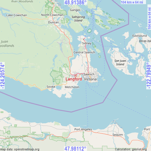
Langford GPS coordinates[2]
48° 26' 58.668" North, 123° 30' 9.396" West
| Map corner | latitude | longitude |
|---|---|---|
| Upper-left | 48.91386°, | -124.20574° |
| Center: | 48.44963°, | -123.50261° |
| Lower-right: | 47.98112°, | -122.79949° |
| Map W x H: | 103.7×103.7 km | = 64.4×64.4mi |
| max Lat: | 73.03752° ⇑42.8% North |
| Langford: | 48.44963° |
| min Lat: | ⇓57.2% South 42.05009° |
| min Long | Langford | max Long |
| -139.43328° | -123.50261° | -52.70931° |
| W 5.1%⇐ | ⇒94.9% E |
Elevation
Elevation of Langford is 80 m = 262 ft, and this is 174.4 m = 572 ft below average elevation for this country.
| Max E: |
1518 m = 4980 ft | 64.3% |
| Avg. | 254.4 m = 835 ft | |
| Langford | 80 m = 262 ft | |
Min E: |
-2 m = -7 ft | 35.7% |
See also: Canada elevation on elevation.city.
Geographical zone
Langford is located in North temperate zone (between Tropic of Cancer and the Arctic Circle). Distance of this North polar circle is 2014.1 km =1251.5 mi to North.| Distance of | km | miles | from Langford |
|---|---|---|---|
| North Pole | 4620 | 2870.7 | to North |
| Arctic Circle | 2014.1 | 1251.5 | to North |
| Tropic Cancer | 2781.2 | 1728.2 | to South |
| Equator | 5387.1 | 3347.4 | to South |


Nearby cities:
15 places around Langford: (largest is in red/bold)
• Chemainus
54.3 km =33.7 mi,  342°
342°
• Cherry Point
29.5 km =18.3 mi,  351°
351°
• Colwood
2.2 km =1.4 mi,  146°
146°
• Cowichan Bay
32.7 km =20.3 mi, 345°
• Duncan
39.9 km =24.8 mi, 338°
• Lake Cowichan
58.2 km =36.2 mi,  315°
315°
• Metchosin
7.8 km =4.8 mi,  198°
198°
• North Cowichan
45.6 km =28.3 mi, 342°
• North Saanich
24.9 km =15.5 mi,  14°
14°
• Oak Bay
14.8 km =9.2 mi,  89°
89°
• Salt Spring Island
41 km =25.5 mi,  1°
1°
• Saltair
58.9 km =36.6 mi, 340°
• Six Mile
3.2 km =2 mi,  73°
73°
• Sooke
18.6 km =11.6 mi,  243°
243°
• Victoria
11.2 km =7 mi,  97°
97°
Sources, notices
• [Note1] Compared only with cities in Canada existing in our database
• [Src1] Map data: © OpenStreetMap contributors (CC-BY-SA)
• [Src2] Other city data from geonames.org with taken over terms of usage.
• [Src3] Geographical zone / Annual Mean Temperature by Robert A. Rohde @ Wikipedia
