Salt Spring Island geodata
Salt Spring Island (British Columbia) is a populated place; located in Canada in America/Vancouver (GMT-7) time zone. With population of 10,557 people, there are 301 cities with bigger population in this country. Compared to other cities in Canada, 60.4% of cities are located further ↓South; 94.9% of cities are located further →East and 57% of cities have higher elevation than Salt Spring Island. Note1


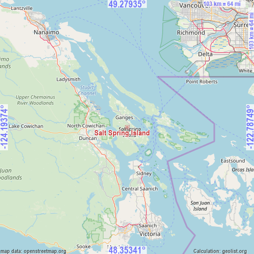
Salt Spring Island GPS coordinates[2]
48° 49' 6.672" North, 123° 29' 26.196" West
| Map corner | latitude | longitude |
|---|---|---|
| Upper-left | 49.27935°, | -124.19374° |
| Center: | 48.81852°, | -123.49061° |
| Lower-right: | 48.35341°, | -122.78749° |
| Map W x H: | 103×103 km | = 64×64mi |
| max Lat: | 73.03752° ⇑39.6% North |
| Salt Spring Island: | 48.81852° |
| min Lat: | ⇓60.4% South 42.05009° |
| min Long | Salt Spring Isl | max Long |
| -139.43328° | -123.49061° | -52.70931° |
| W 5.1%⇐ | ⇒94.9% E |
Elevation
Elevation of Salt Spring Island is 122 m = 400 ft, and this is 132.4 m = 434 ft below average elevation for this country.
| Max E: |
1518 m = 4980 ft | 57% |
| Avg. | 254.4 m = 835 ft | |
| Salt Spring Island | 122 m = 400 ft | |
Min E: |
-2 m = -7 ft | 43% |
See also: Canada elevation on elevation.city.
Geographical zone
Salt Spring Island is located in North temperate zone (between Tropic of Cancer and the Arctic Circle). Distance of this North polar circle is 1973.1 km =1226 mi to North.| Distance of | km | miles | from Salt Spring Island |
|---|---|---|---|
| North Pole | 4579 | 2845.3 | to North |
| Arctic Circle | 1973.1 | 1226 | to North |
| Tropic Cancer | 2822.2 | 1753.6 | to South |
| Equator | 5428.1 | 3372.9 | to South |


Nearby cities:
15 places around Salt Spring Island: (largest is in red/bold)
• Cassidy
38.7 km =24 mi,  311°
311°
• Chemainus
20 km =12.4 mi,  303°
303°
• Cherry Point
12.8 km =8 mi,  202°
202°
• Cowichan Bay
13.2 km =8.2 mi,  224°
224°
• Duncan
16 km =9.9 mi,  255°
255°
• Ladner
42.4 km =26.3 mi,  44°
44°
• Ladysmith
30.5 km =19 mi, 308°
• Lake Cowichan
41.3 km =25.7 mi,  270°
270°
• Langford
41 km =25.5 mi,  181°
181°
• North Cowichan
14.5 km =9 mi,  280°
280°
• North Oyster/Yellow Point
35.8 km =22.2 mi,  315°
315°
• North Saanich
17.7 km =11 mi,  162°
162°
• Saltair
25.1 km =15.6 mi, 305°
• Six Mile
40.2 km =25 mi, 176°
• Tsawwassen
37 km =23 mi,  53°
53°
Sources, notices
• [Note1] Compared only with cities in Canada existing in our database
• [Src1] Map data: © OpenStreetMap contributors (CC-BY-SA)
• [Src2] Other city data from geonames.org with taken over terms of usage.
• [Src3] Geographical zone / Annual Mean Temperature by Robert A. Rohde @ Wikipedia
