Victoria geodata
Victoria (British Columbia) is a seat of a first-order administrative division; located in Canada in America/Vancouver (GMT-7) time zone. With population of 289,625 people, there are 20 cities with bigger population in this country. Compared to other cities in Canada, 57.1% of cities are located further ↓South; 94.3% of cities are located further →East and 75.8% of cities have higher elevation than Victoria. Note1


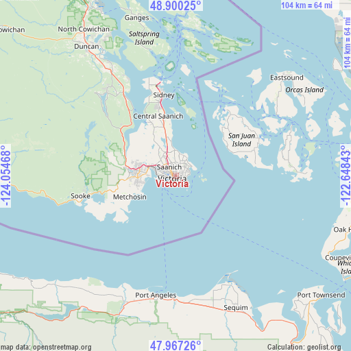
Victoria GPS coordinates[2]
48° 26' 9.24" North, 123° 21' 5.58" West
| Map corner | latitude | longitude |
|---|---|---|
| Upper-left | 48.90025°, | -124.05468° |
| Center: | 48.4359°, | -123.35155° |
| Lower-right: | 47.96726°, | -122.64843° |
| Map W x H: | 103.7×103.7 km | = 64.4×64.4mi |
| max Lat: | 73.03752° ⇑42.9% North |
| Victoria: | 48.4359° |
| min Lat: | ⇓57.1% South 42.05009° |
| min Long | Victoria | max Long |
| -139.43328° | -123.35155° | -52.70931° |
| W 5.7%⇐ | ⇒94.3% E |
Elevation
Elevation of Victoria is 41 m = 135 ft, and this is 213.4 m = 700 ft below average elevation for this country.
| Max E: |
1518 m = 4980 ft | 75.8% |
| Avg. | 254.4 m = 835 ft | |
| Victoria | 41 m = 135 ft | |
Min E: |
-2 m = -7 ft | 24.2% |
See also: Victoria elevation on elevation.city.
Geographical zone
Victoria is located in North temperate zone (between Tropic of Cancer and the Arctic Circle). Distance of this North polar circle is 2015.6 km =1252.4 mi to North.| Distance of | km | miles | from Victoria |
|---|---|---|---|
| North Pole | 4621.5 | 2871.7 | to North |
| Arctic Circle | 2015.6 | 1252.4 | to North |
| Tropic Cancer | 2779.6 | 1727.2 | to South |
| Equator | 5385.6 | 3346.5 | to South |


Nearby cities:
15 places around Victoria: (largest is in red/bold)
• Chemainus
59.9 km =37.2 mi,  333°
333°
• Cherry Point
34.3 km =21.3 mi, 333°
• Colwood
9.9 km =6.2 mi,  268°
268°
• Cowichan Bay
38.5 km =23.9 mi, 329°
• Duncan
46.4 km =28.8 mi, 326°
• Lake Cowichan
67.4 km =41.9 mi,  309°
309°
• Langford
11.2 km =7 mi,  277°
277°
• Metchosin
14.8 km =9.2 mi,  246°
246°
• North Cowichan
51.3 km =31.9 mi, 331°
• North Saanich
26.1 km =16.2 mi,  348°
348°
• Oak Bay
3.9 km =2.4 mi,  67°
67°
• Salt Spring Island
43.8 km =27.2 mi, 346°
• Saltair
64.8 km =40.3 mi, 331°
• Six Mile
8.4 km =5.2 mi,  286°
286°
• Sooke
28.6 km =17.8 mi,  256°
256°
Sources, notices
• [Note1] Compared only with cities in Canada existing in our database
• [Src1] Map data: © OpenStreetMap contributors (CC-BY-SA)
• [Src2] Other city data from geonames.org with taken over terms of usage.
• [Src3] Geographical zone / Annual Mean Temperature by Robert A. Rohde @ Wikipedia
