Truro geodata
Truro (Nova Scotia) is a populated place; located in Canada in America/Halifax (GMT-3) time zone. With population of 20,650 people, there are 184 cities with bigger population in this country. Compared to other cities in Canada, 79% of cities are located further ↑North; 95.4% of cities are located further ←West and 88.3% of cities have higher elevation than Truro. Note1


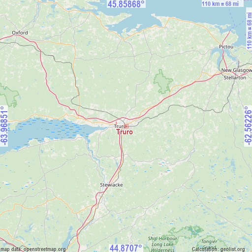
Truro GPS coordinates[2]
45° 22' 0.66" North, 63° 15' 55.368" West
| Map corner | latitude | longitude |
|---|---|---|
| Upper-left | 45.85868°, | -63.96851° |
| Center: | 45.36685°, | -63.26538° |
| Lower-right: | 44.8707°, | -62.56226° |
| Map W x H: | 109.9×109.9 km | = 68.3×68.3mi |
| max Lat: | 73.03752° ⇑79% North |
| Truro: | 45.36685° |
| min Lat: | ⇓21% South 42.05009° |
| min Long | Truro | max Long |
| -139.43328° | -63.26538° | -52.70931° |
| W 95.4%⇐ | ⇒4.6% E |
Elevation
Elevation of Truro is 17 m = 56 ft, and this is 237.4 m = 779 ft below average elevation for this country.
| Max E: |
1518 m = 4980 ft | 88.3% |
| Avg. | 254.4 m = 835 ft | |
| Truro | 17 m = 56 ft | |
Min E: |
-2 m = -7 ft | 11.7% |
See also: Canada elevation on elevation.city.
Geographical zone
Truro is located in North temperate zone (between Tropic of Cancer and the Arctic Circle). Distance of this North polar circle is 2356.9 km =1464.5 mi to North.| Distance of | km | miles | from Truro |
|---|---|---|---|
| North Pole | 4962.7 | 3083.7 | to North |
| Arctic Circle | 2356.9 | 1464.5 | to North |
| Tropic Cancer | 2438.4 | 1515.2 | to South |
| Equator | 5044.3 | 3134.4 | to South |


Nearby cities:
15 places around Truro: (largest is in red/bold)
• Cole Harbour
79 km =49.1 mi,  192°
192°
• Dartmouth
81.1 km =50.4 mi,  197°
197°
• English Corner
81.3 km =50.5 mi,  209°
209°
• Fall River
67 km =41.6 mi, 204°
• Hantsport
78 km =48.5 mi,  244°
244°
• Lake Echo
71 km =44.1 mi, 187°
• Lantz
45.9 km =28.5 mi, 201°
• Lower Sackville
73.3 km =45.5 mi, 206°
• Middleton
39.5 km =24.5 mi,  9°
9°
• New Glasgow
53.8 km =33.4 mi,  63°
63°
• Oxford
62 km =38.5 mi,  311°
311°
• Pictou
55.5 km =34.5 mi,  51°
51°
• Springhill
68.7 km =42.7 mi,  297°
297°
• Waverley
69.9 km =43.4 mi, 201°
• Windsor
80.2 km =49.8 mi, 237°
Sources, notices
• [Note1] Compared only with cities in Canada existing in our database
• [Src1] Map data: © OpenStreetMap contributors (CC-BY-SA)
• [Src2] Other city data from geonames.org with taken over terms of usage.
• [Src3] Geographical zone / Annual Mean Temperature by Robert A. Rohde @ Wikipedia
