Pointe-Calumet geodata
Pointe-Calumet (Quebec) is a populated place; located in Canada in America/Toronto (GMT-4) time zone. With population of 6,396 people, there are 417 cities with bigger population in this country. Compared to other cities in Canada, 74.8% of cities are located further ↑North; 62.7% of cities are located further ←West and 84.5% of cities have higher elevation than Pointe-Calumet. Note1


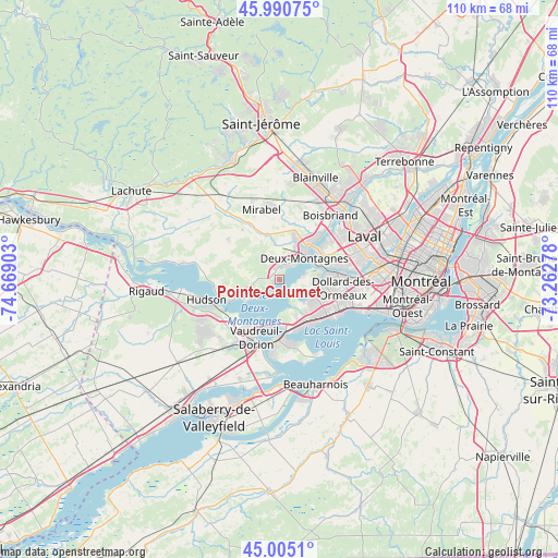
Pointe-Calumet GPS coordinates[2]
45° 30' 0.288" North, 73° 57' 57.24" West
| Map corner | latitude | longitude |
|---|---|---|
| Upper-left | 45.99075°, | -74.66903° |
| Center: | 45.50008°, | -73.9659° |
| Lower-right: | 45.0051°, | -73.26278° |
| Map W x H: | 109.6×109.6 km | = 68.1×68.1mi |
| max Lat: | 73.03752° ⇑74.8% North |
| Pointe-Calumet: | 45.50008° |
| min Lat: | ⇓25.2% South 42.05009° |
| min Long | Pointe-Calumet | max Long |
| -139.43328° | -73.9659° | -52.70931° |
| W 62.7%⇐ | ⇒37.3% E |
Elevation
Elevation of Pointe-Calumet is 23 m = 75 ft, and this is 231.4 m = 759 ft below average elevation for this country.
| Max E: |
1518 m = 4980 ft | 84.5% |
| Avg. | 254.4 m = 835 ft | |
| Pointe-Calumet | 23 m = 75 ft | |
Min E: |
-2 m = -7 ft | 15.5% |
See also: Canada elevation on elevation.city.
Geographical zone
Pointe-Calumet is located in North temperate zone (between Tropic of Cancer and the Arctic Circle). Distance of this North polar circle is 2342 km =1455.3 mi to North.| Distance of | km | miles | from Pointe-Calumet |
|---|---|---|---|
| North Pole | 4947.9 | 3074.5 | to North |
| Arctic Circle | 2342 | 1455.3 | to North |
| Tropic Cancer | 2453.2 | 1524.3 | to South |
| Equator | 5059.1 | 3143.6 | to South |


Nearby cities:
15 places around Pointe-Calumet: (largest is in red/bold)
• Baie-D'Urfé
10.3 km =6.4 mi,  157°
157°
• Beaconsfield
10.8 km =6.7 mi,  133°
133°
• Deux-Montagnes
6.3 km =3.9 mi,  52°
52°
• Dollard-Des Ormeaux
11.1 km =6.9 mi,  93°
93°
• Kirkland
9.6 km =6 mi, 125°
• L'Île-Perrot
13 km =8.1 mi,  174°
174°
• Oka
10.4 km =6.5 mi,  247°
247°
• Pincourt
13 km =8.1 mi,  185°
185°
• Pointe-Claire
13 km =8.1 mi,  116°
116°
• Saint-Eustache
8.6 km =5.3 mi,  33°
33°
• Saint-Jean-Baptiste
13.8 km =8.6 mi,  195°
195°
• Saint-Joseph-du-Lac
4.5 km =2.8 mi,  324°
324°
• Sainte-Anne-de-Bellevue
10.6 km =6.6 mi, 171°
• Sainte-Marthe-sur-le-Lac
4.5 km =2.8 mi,  35°
35°
• Vaudreuil-Dorion
12.3 km =7.6 mi,  205°
205°
Sources, notices
• [Note1] Compared only with cities in Canada existing in our database
• [Src1] Map data: © OpenStreetMap contributors (CC-BY-SA)
• [Src2] Other city data from geonames.org with taken over terms of usage.
• [Src3] Geographical zone / Annual Mean Temperature by Robert A. Rohde @ Wikipedia
