Les Cèdres geodata
Les Cèdres (Quebec) is a populated place; located in Canada in America/Toronto (GMT-4) time zone. With population of 1,434 people, there are 880 cities with bigger population in this country. Compared to other cities in Canada, 81.1% of cities are located further ↑North; 62% of cities are located further ←West and 81.3% of cities have higher elevation than Les Cèdres. Note1


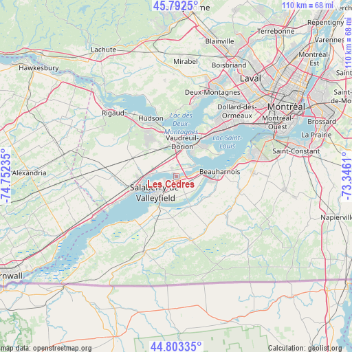
Les Cèdres GPS coordinates[2]
45° 18' 0.288" North, 74° 2' 57.192" West
| Map corner | latitude | longitude |
|---|---|---|
| Upper-left | 45.7925°, | -74.75235° |
| Center: | 45.30008°, | -74.04922° |
| Lower-right: | 44.80335°, | -73.3461° |
| Map W x H: | 110×110 km | = 68.4×68.4mi |
| max Lat: | 73.03752° ⇑81.1% North |
| Les Cèdres: | 45.30008° |
| min Lat: | ⇓18.9% South 42.05009° |
| min Long | Les Cèdres | max Long |
| -139.43328° | -74.04922° | -52.70931° |
| W 62%⇐ | ⇒38% E |
Elevation
Elevation of Les Cèdres is 30 m = 98 ft, and this is 224.4 m = 736 ft below average elevation for this country.
| Max E: |
1518 m = 4980 ft | 81.3% |
| Avg. | 254.4 m = 835 ft | |
| Les Cèdres | 30 m = 98 ft | |
Min E: |
-2 m = -7 ft | 18.7% |
See also: Canada elevation on elevation.city.
Geographical zone
Les Cèdres is located in North temperate zone (between Tropic of Cancer and the Arctic Circle). Distance of this North polar circle is 2364.3 km =1469.1 mi to North.| Distance of | km | miles | from Les Cèdres |
|---|---|---|---|
| North Pole | 4970.2 | 3088.3 | to North |
| Arctic Circle | 2364.3 | 1469.1 | to North |
| Tropic Cancer | 2431 | 1510.6 | to South |
| Equator | 5036.9 | 3129.8 | to South |


Nearby cities:
15 places around Les Cèdres: (largest is in red/bold)
• Baie-D'Urfé
16.4 km =10.2 mi,  39°
39°
• Beauharnois
13.9 km =8.6 mi,  83°
83°
• Coteau-du-Lac
10.4 km =6.5 mi,  270°
270°
• Hudson
18.4 km =11.4 mi,  334°
334°
• L'Île-Perrot
12.1 km =7.5 mi, 40°
• Les Coteaux
14.5 km =9 mi,  262°
262°
• Melocheville
9 km =5.6 mi, 77°
• Notre-Dame-de-l'Île-Perrot
11.8 km =7.3 mi,  50°
50°
• Pincourt
10.6 km =6.6 mi,  29°
29°
• Saint-Jean-Baptiste
9.4 km =5.8 mi,  17°
17°
• Saint-Lazare
12.9 km =8 mi, 329°
• Saint-Zotique
16.6 km =10.3 mi,  250°
250°
• Sainte-Anne-de-Bellevue
14.3 km =8.9 mi, 34°
• Salaberry-de-Valleyfield
8.6 km =5.3 mi,  229°
229°
• Vaudreuil-Dorion
11.2 km =7 mi,  6°
6°
Sources, notices
• [Note1] Compared only with cities in Canada existing in our database
• [Src1] Map data: © OpenStreetMap contributors (CC-BY-SA)
• [Src2] Other city data from geonames.org with taken over terms of usage.
• [Src3] Geographical zone / Annual Mean Temperature by Robert A. Rohde @ Wikipedia
