Millet geodata
Millet (Alberta) is a populated place; located in Canada in America/Edmonton (GMT-6) time zone. With population of 1,905 people, there are 766 cities with bigger population in this country. Compared to other cities in Canada, 89.5% of cities are located further ↓South; 79.5% of cities are located further →East and 93.9% of cities have lower elevation than Millet. Note1


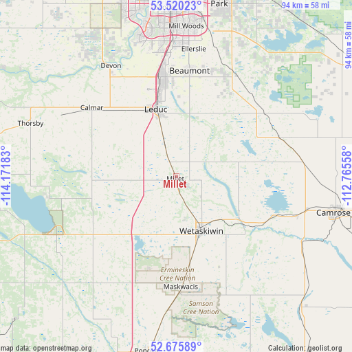
Millet GPS coordinates[2]
53° 6' 0.468" North, 113° 28' 7.32" West
| Map corner | latitude | longitude |
|---|---|---|
| Upper-left | 53.52023°, | -114.17183° |
| Center: | 53.10013°, | -113.4687° |
| Lower-right: | 52.67589°, | -112.76558° |
| Map W x H: | 93.9×93.9 km | = 58.3×58.3mi |
| max Lat: | 73.03752° ⇑10.5% North |
| Millet: | 53.10013° |
| min Lat: | ⇓89.5% South 42.05009° |
| min Long | Millet | max Long |
| -139.43328° | -113.4687° | -52.70931° |
| W 20.5%⇐ | ⇒79.5% E |
Elevation
Elevation of Millet is 753 m = 2470 ft, and this is 498.6 m = 1636 ft above average elevation for this country.
| Max E: |
1518 m = 4980 ft | 6.1% |
| Millet | 753 m 2470 ft | |
| Avg. | 254.4 m = 835 ft | |
Min E: |
-2 m = -7 ft | 93.9% |
See also: Canada elevation on elevation.city.
Geographical zone
Millet is located in North temperate zone (between Tropic of Cancer and the Arctic Circle). Distance of this North polar circle is 1497 km =930.2 mi to North.| Distance of | km | miles | from Millet |
|---|---|---|---|
| North Pole | 4102.9 | 2549.4 | to North |
| Arctic Circle | 1497 | 930.2 | to North |
| Tropic Cancer | 3298.3 | 2049.5 | to South |
| Equator | 5904.2 | 3668.7 | to South |


Nearby cities:
15 places around Millet: (largest is in red/bold)
• Beaumont
28 km =17.4 mi,  6°
6°
• Calmar
29.8 km =18.5 mi,  308°
308°
• Camrose
43.3 km =26.9 mi,  102°
102°
• Devon
34.6 km =21.5 mi,  329°
329°
• Larkspur
42.6 km =26.5 mi, 7°
• Laurel
39 km =24.2 mi, 8°
• Leduc
19.3 km =12 mi,  343°
343°
• Maple Ridge
45.2 km =28.1 mi, 8°
• Mill Woods Town Centre
39.7 km =24.7 mi,  3°
3°
• Rideau Park
42.2 km =26.2 mi,  356°
356°
• Sherwood Park
47.4 km =29.5 mi, 12°
• Silver Berry
40.2 km =25 mi, 8°
• Tamarack
41.1 km =25.5 mi, 9°
• Wetaskiwin
16.3 km =10.1 mi,  155°
155°
• Wild Rose
41.6 km =25.8 mi, 8°
Sources, notices
• [Note1] Compared only with cities in Canada existing in our database
• [Src1] Map data: © OpenStreetMap contributors (CC-BY-SA)
• [Src2] Other city data from geonames.org with taken over terms of usage.
• [Src3] Geographical zone / Annual Mean Temperature by Robert A. Rohde @ Wikipedia
