Beaumont geodata
Beaumont (Alberta) is a populated place; located in Canada in America/Edmonton (GMT-6) time zone. With population of 7,366 people, there are 388 cities with bigger population in this country. Compared to other cities in Canada, 90.4% of cities are located further ↓South; 79.2% of cities are located further →East and 92.7% of cities have lower elevation than Beaumont. Note1


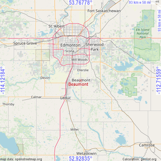
Beaumont GPS coordinates[2]
53° 21' 0.468" North, 113° 25' 7.356" West
| Map corner | latitude | longitude |
|---|---|---|
| Upper-left | 53.76778°, | -114.12184° |
| Center: | 53.35013°, | -113.41871° |
| Lower-right: | 52.92835°, | -112.71559° |
| Map W x H: | 93.3×93.3 km | = 58×58mi |
| max Lat: | 73.03752° ⇑9.6% North |
| Beaumont: | 53.35013° |
| min Lat: | ⇓90.4% South 42.05009° |
| min Long | Beaumont | max Long |
| -139.43328° | -113.41871° | -52.70931° |
| W 20.8%⇐ | ⇒79.2% E |
Elevation
Elevation of Beaumont is 716 m = 2349 ft, and this is 461.6 m = 1514 ft above average elevation for this country.
| Max E: |
1518 m = 4980 ft | 7.3% |
| Beaumont | 716 m 2349 ft | |
| Avg. | 254.4 m = 835 ft | |
Min E: |
-2 m = -7 ft | 92.7% |
See also: Canada elevation on elevation.city.
Geographical zone
Beaumont is located in North temperate zone (between Tropic of Cancer and the Arctic Circle). Distance of this North polar circle is 1469.2 km =912.9 mi to North.| Distance of | km | miles | from Beaumont |
|---|---|---|---|
| North Pole | 4075.1 | 2532.1 | to North |
| Arctic Circle | 1469.2 | 912.9 | to North |
| Tropic Cancer | 3326.1 | 2066.7 | to South |
| Equator | 5932 | 3686 | to South |


Nearby cities:
15 places around Beaumont: (largest is in red/bold)
• Calmar
28.1 km =17.5 mi,  250°
250°
• Devon
21.1 km =13.1 mi,  275°
275°
• Edmonton
22.5 km =14 mi,  351°
351°
• Larkspur
14.6 km =9.1 mi,  9°
9°
• Laurel
11 km =6.8 mi, 12°
• Leduc
12.8 km =8 mi,  223°
223°
• Maple Ridge
17.3 km =10.7 mi, 12°
• Mill Woods Town Centre
11.8 km =7.3 mi,  357°
357°
• Millet
28 km =17.4 mi,  186°
186°
• Rideau Park
15.4 km =9.6 mi,  338°
338°
• Sherwood Park
19.7 km =12.2 mi,  19°
19°
• Silver Berry
12.2 km =7.6 mi, 11°
• St. Albert
34.6 km =21.5 mi, 335°
• Tamarack
13.2 km =8.2 mi, 16°
• Wild Rose
13.6 km =8.5 mi, 10°
Sources, notices
• [Note1] Compared only with cities in Canada existing in our database
• [Src1] Map data: © OpenStreetMap contributors (CC-BY-SA)
• [Src2] Other city data from geonames.org with taken over terms of usage.
• [Src3] Geographical zone / Annual Mean Temperature by Robert A. Rohde @ Wikipedia
