Tamarack geodata
Tamarack (Alberta) is a section of populated place; located in Canada in America/Edmonton (GMT-6) time zone. With population of 2,348 people, there are 696 cities with bigger population in this country. Compared to other cities in Canada, 91.2% of cities are located further ↓South; 78.5% of cities are located further →East and 92.3% of cities have lower elevation than Tamarack. Note1


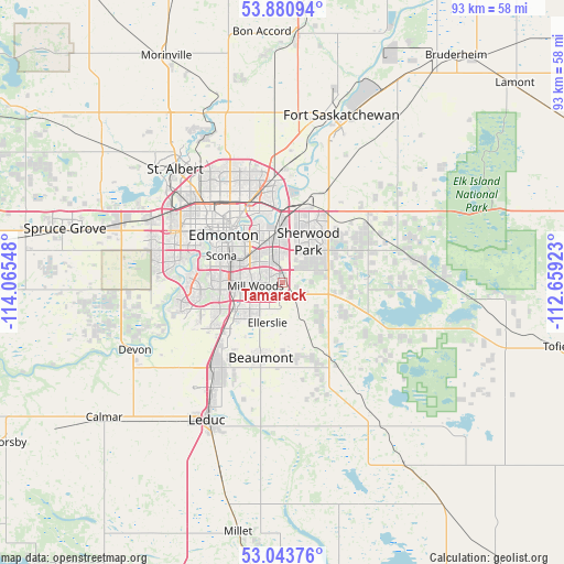
Tamarack GPS coordinates[2]
53° 27' 51.876" North, 113° 21' 44.46" West
| Map corner | latitude | longitude |
|---|---|---|
| Upper-left | 53.88094°, | -114.06548° |
| Center: | 53.46441°, | -113.36235° |
| Lower-right: | 53.04376°, | -112.65923° |
| Map W x H: | 93.1×93.1 km | = 57.8×57.8mi |
| max Lat: | 73.03752° ⇑8.8% North |
| Tamarack: | 53.46441° |
| min Lat: | ⇓91.2% South 42.05009° |
| min Long | Tamarack | max Long |
| -139.43328° | -113.36235° | -52.70931° |
| W 21.5%⇐ | ⇒78.5% E |
Elevation
Elevation of Tamarack is 710 m = 2329 ft, and this is 455.6 m = 1495 ft above average elevation for this country.
| Max E: |
1518 m = 4980 ft | 7.7% |
| Tamarack | 710 m 2329 ft | |
| Avg. | 254.4 m = 835 ft | |
Min E: |
-2 m = -7 ft | 92.3% |
See also: Canada elevation on elevation.city.
Geographical zone
Tamarack is located in North temperate zone (between Tropic of Cancer and the Arctic Circle). Distance of this North polar circle is 1456.5 km =905 mi to North.| Distance of | km | miles | from Tamarack |
|---|---|---|---|
| North Pole | 4062.4 | 2524.3 | to North |
| Arctic Circle | 1456.5 | 905 | to North |
| Tropic Cancer | 3338.8 | 2074.6 | to South |
| Equator | 5944.7 | 3693.9 | to South |


Nearby cities:
15 places around Tamarack: (largest is in red/bold)
• Beaumont
13.2 km =8.2 mi,  196°
196°
• Calmar
37.4 km =23.2 mi,  234°
234°
• Devon
27 km =16.8 mi,  246°
246°
• Edmonton
11.8 km =7.3 mi,  323°
323°
• Fort Saskatchewan
29.6 km =18.4 mi,  18°
18°
• Larkspur
2.1 km =1.3 mi, 322°
• Laurel
2.4 km =1.5 mi,  213°
213°
• Leduc
25.3 km =15.7 mi, 209°
• Maple Ridge
4.1 km =2.5 mi,  359°
359°
• Mill Woods Town Centre
4.4 km =2.7 mi,  258°
258°
• Rideau Park
9.6 km =6 mi,  279°
279°
• Sherwood Park
6.5 km =4 mi,  26°
26°
• Silver Berry
1.5 km =0.9 mi,  240°
240°
• St. Albert
26 km =16.2 mi, 316°
• Wild Rose
1.4 km =0.9 mi,  299°
299°
Sources, notices
• [Note1] Compared only with cities in Canada existing in our database
• [Src1] Map data: © OpenStreetMap contributors (CC-BY-SA)
• [Src2] Other city data from geonames.org with taken over terms of usage.
• [Src3] Geographical zone / Annual Mean Temperature by Robert A. Rohde @ Wikipedia
