Sherwood Park geodata
Sherwood Park (Alberta) is a populated place; located in Canada in America/Edmonton (GMT-6) time zone. With population of 55,063 people, there are 94 cities with bigger population in this country. Compared to other cities in Canada, 91.7% of cities are located further ↓South; 78.3% of cities are located further →East and 93% of cities have lower elevation than Sherwood Park. Note1


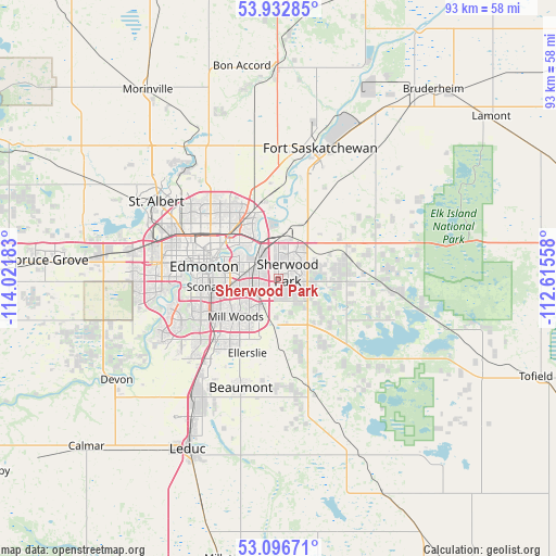
Sherwood Park GPS coordinates[2]
53° 31' 0.624" North, 113° 19' 7.32" West
| Map corner | latitude | longitude |
|---|---|---|
| Upper-left | 53.93285°, | -114.02183° |
| Center: | 53.51684°, | -113.3187° |
| Lower-right: | 53.09671°, | -112.61558° |
| Map W x H: | 93×93 km | = 57.8×57.8mi |
| max Lat: | 73.03752° ⇑8.3% North |
| Sherwood Park: | 53.51684° |
| min Lat: | ⇓91.7% South 42.05009° |
| min Long | Sherwood Park | max Long |
| -139.43328° | -113.3187° | -52.70931° |
| W 21.7%⇐ | ⇒78.3% E |
Elevation
Elevation of Sherwood Park is 722 m = 2369 ft, and this is 467.6 m = 1534 ft above average elevation for this country.
| Max E: |
1518 m = 4980 ft | 7% |
| Sherwood Park | 722 m 2369 ft | |
| Avg. | 254.4 m = 835 ft | |
Min E: |
-2 m = -7 ft | 93% |
See also: Sherwood Park elevation on elevation.city.
Geographical zone
Sherwood Park is located in North temperate zone (between Tropic of Cancer and the Arctic Circle). Distance of this North polar circle is 1450.7 km =901.4 mi to North.| Distance of | km | miles | from Sherwood Park |
|---|---|---|---|
| North Pole | 4056.5 | 2520.6 | to North |
| Arctic Circle | 1450.7 | 901.4 | to North |
| Tropic Cancer | 3344.6 | 2078.2 | to South |
| Equator | 5950.5 | 3697.5 | to South |


Nearby cities:
15 places around Sherwood Park: (largest is in red/bold)
• Beaumont
19.7 km =12.2 mi,  199°
199°
• Devon
32.2 km =20 mi,  238°
238°
• Edmonton
10.6 km =6.6 mi,  290°
290°
• Fort Saskatchewan
23.2 km =14.4 mi,  16°
16°
• Gibbons
35.2 km =21.9 mi,  358°
358°
• Larkspur
5.9 km =3.7 mi,  224°
224°
• Laurel
8.9 km =5.5 mi,  208°
208°
• Leduc
31.8 km =19.8 mi, 209°
• Maple Ridge
3.4 km =2.1 mi, 240°
• Mill Woods Town Centre
9.8 km =6.1 mi,  226°
226°
• Rideau Park
13 km =8.1 mi,  251°
251°
• Silver Berry
7.8 km =4.8 mi, 212°
• St. Albert
24.6 km =15.3 mi,  301°
301°
• Tamarack
6.5 km =4 mi, 206°
• Wild Rose
6.6 km =4.1 mi, 218°
Sources, notices
• [Note1] Compared only with cities in Canada existing in our database
• [Src1] Map data: © OpenStreetMap contributors (CC-BY-SA)
• [Src2] Other city data from geonames.org with taken over terms of usage.
• [Src3] Geographical zone / Annual Mean Temperature by Robert A. Rohde @ Wikipedia
