Niagara Falls geodata
Niagara Falls (Ontario) is a populated place; located in Canada in America/Toronto (GMT-4) time zone. With population of 82,000 people, there are 66 cities with bigger population in this country. Compared to other cities in Canada, 97.2% of cities are located further ↑North; 50.1% of cities are located further →East and 52.5% of cities have lower elevation than Niagara Falls. Note1


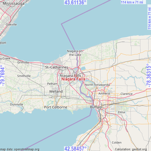
Niagara Falls GPS coordinates[2]
43° 6' 0.432" North, 79° 3' 58.572" West
| Map corner | latitude | longitude |
|---|---|---|
| Upper-left | 43.61136°, | -79.7694° |
| Center: | 43.10012°, | -79.06627° |
| Lower-right: | 42.58457°, | -78.36315° |
| Map W x H: | 114.2×114.2 km | = 71×71mi |
| max Lat: | 73.03752° ⇑97.2% North |
| Niagara Falls: | 43.10012° |
| min Lat: | ⇓2.8% South 42.05009° |
| min Long | Niagara Falls | max Long |
| -139.43328° | -79.06627° | -52.70931° |
| W 49.9%⇐ | ⇒50.1% E |
Elevation
Elevation of Niagara Falls is 184 m = 604 ft, and this is 70.4 m = 231 ft below average elevation for this country.
| Max E: |
1518 m = 4980 ft | 47.5% |
| Avg. | 254.4 m = 835 ft | |
| Niagara Falls | 184 m = 604 ft | |
Min E: |
-2 m = -7 ft | 52.5% |
See also: Niagara Falls elevation on elevation.city.
Geographical zone
Niagara Falls is located in North temperate zone (between Tropic of Cancer and the Arctic Circle). Distance of this Northern Tropic circle is 2186.4 km =1358.6 mi to South.| Distance of | km | miles | from Niagara Falls |
|---|---|---|---|
| North Pole | 5214.8 | 3240.3 | to North |
| Arctic Circle | 2608.9 | 1621.1 | to North |
| Tropic Cancer | 2186.4 | 1358.6 | to South |
| Equator | 4792.3 | 2977.8 | to South |


Nearby cities:
15 places around Niagara Falls: (largest is in red/bold)
• Binbrook
60.5 km =37.6 mi,  272°
272°
• Burlington
70.1 km =43.6 mi,  296°
296°
• East York
69 km =42.9 mi,  342°
342°
• Fort Erie
24.7 km =15.3 mi,  153°
153°
• Hamilton
65.7 km =40.8 mi,  284°
284°
• Mississauga
71.6 km =44.5 mi,  318°
318°
• Mississauga Beach
18.6 km =11.6 mi,  355°
355°
• Oakville
63.3 km =39.3 mi,  307°
307°
• Port Colborne
26 km =16.2 mi,  211°
211°
• St. Catharines
16.4 km =10.2 mi, 298°
• Thorold
11 km =6.8 mi, 279°
• Thunder Bay
24.6 km =15.3 mi,  173°
173°
• Vineland
27.6 km =17.1 mi, 281°
• Virgil
14.1 km =8.8 mi, 337°
• Welland
19.8 km =12.3 mi,  228°
228°
Sources, notices
• [Note1] Compared only with cities in Canada existing in our database
• [Src1] Map data: © OpenStreetMap contributors (CC-BY-SA)
• [Src2] Other city data from geonames.org with taken over terms of usage.
• [Src3] Geographical zone / Annual Mean Temperature by Robert A. Rohde @ Wikipedia
